You are here: Home > Network List > AU - Australian Seismological Centre Stations List
> Station COOLG Geological Survey of Western Station > Earthquake Result Viewer
COOLG Geological Survey of Western Station - Earthquake Result Viewer
| Earthquake location: |
Philippine Islands Region |
| Earthquake latitude/longitude: |
13.8/125.5 |
| Earthquake time(UTC): |
2023/04/04 (094) 12:54:32 GMT |
| Earthquake Depth: |
15 km |
| Earthquake Magnitude: |
6.2 mww |
| Earthquake Catalog/Contributor: |
NEIC PDE/us |
|
| Network: |
AU Australian Seismological Centre |
| Station: |
COOLG Geological Survey of Western Station |
| Lat/Lon: |
30.96 S/121.18 E |
| Elevation: |
415 m |
|
| Distance: |
44.7 deg |
| Az: |
185.337 deg |
| Baz: |
6.04 deg |
| Ray Param: |
0.07178193 |
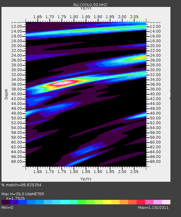
| Estimated Moho Depth: |
35.0 km |
| Estimated Crust Vp/Vs: |
1.75 |
| Assumed Crust Vp: |
6.459 km/s |
| Estimated Crust Vs: |
3.686 km/s |
| Estimated Crust Poisson's Ratio: |
0.26 |
|
| Radial Match: |
89.925354 % |
| Radial Bump: |
335 |
| Transverse Match: |
77.45105 % |
| Transverse Bump: |
400 |
| SOD ConfigId: |
30536071 |
| Insert Time: |
2023-04-18 12:59:39.966 +0000 |
| GWidth: |
2.5 |
| Max Bumps: |
400 |
| Tol: |
0.001 |
|

Signal To Noise
| Channel | StoN | STA | LTA |
| AU:COOLG:00:HHZ:20230404T13:02:13.609989Z | 9.343232 | 2.6774321E-6 | 2.865638E-7 |
| AU:COOLG:00:HHN:20230404T13:02:13.609989Z | 10.45462 | 1.662361E-6 | 1.5900731E-7 |
| AU:COOLG:00:HHE:20230404T13:02:13.609989Z | 3.396247 | 4.3117316E-7 | 1.2695577E-7 |
| Arrivals |
| Ps | 4.4 SECOND |
| PpPs | 14 SECOND |
| PsPs/PpSs | 18 SECOND |


