You are here: Home > Network List > TA - USArray Transportable Network (new EarthScope stations) Stations List
> Station J20A Shoshoni, WY, USA > Earthquake Result Viewer
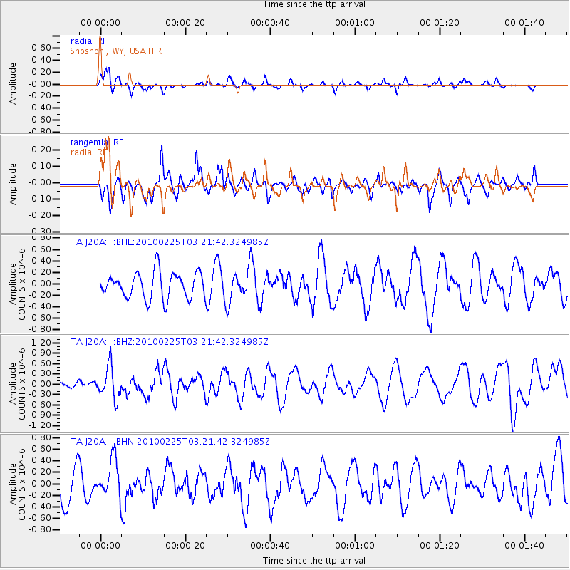
J20A Shoshoni, WY, USA - Earthquake Result Viewer
*The percent match for this event was below the threshold and hence no stack was calculated.
| Earthquake location: |
Near Coast Of Nicaragua |
| Earthquake latitude/longitude: |
11.2/-86.1 |
| Earthquake time(UTC): |
2010/02/25 (056) 03:15:03 GMT |
| Earthquake Depth: |
25 km |
| Earthquake Magnitude: |
5.6 MW, 5.3 MS, 5.4 MB, 5.6 MW |
| Earthquake Catalog/Contributor: |
WHDF/NEIC |
|
| Network: |
TA USArray Transportable Network (new EarthScope stations) |
| Station: |
J20A Shoshoni, WY, USA |
| Lat/Lon: |
43.35 N/108.08 W |
| Elevation: |
1500 m |
|
| Distance: |
37.3 deg |
| Az: |
333.243 deg |
| Baz: |
142.724 deg |
| Ray Param: |
$rayparam |
*The percent match for this event was below the threshold and hence was not used in the summary stack. |
|
| Radial Match: |
47.600445 % |
| Radial Bump: |
336 |
| Transverse Match: |
46.877377 % |
| Transverse Bump: |
353 |
| SOD ConfigId: |
307546 |
| Insert Time: |
2010-05-14 07:57:34.354 +0000 |
| GWidth: |
2.5 |
| Max Bumps: |
400 |
| Tol: |
0.001 |
|
Signal To Noise
| Channel | StoN | STA | LTA |
| TA:J20A: :BHZ:20100225T03:21:42.324985Z | 4.1170745 | 4.736784E-7 | 1.1505219E-7 |
| TA:J20A: :BHN:20100225T03:21:42.324985Z | 1.2112967 | 3.3762416E-7 | 2.7872954E-7 |
| TA:J20A: :BHE:20100225T03:21:42.324985Z | 1.0668129 | 2.4069212E-7 | 2.2561792E-7 |
| Arrivals |
| Ps | |
| PpPs | |
| PsPs/PpSs | |


