You are here: Home > Network List > AV - Alaska Volcano Observatory Stations List
> Station SPCR Ckakachatna River, Mount Spurr, Alaska > Earthquake Result Viewer
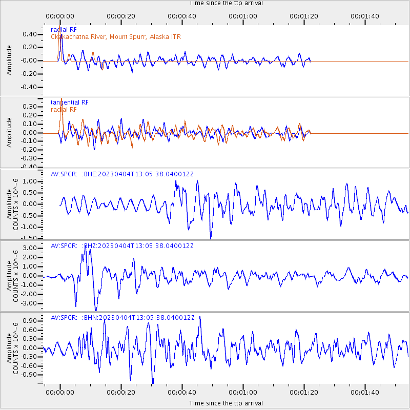
SPCR Ckakachatna River, Mount Spurr, Alaska - Earthquake Result Viewer
*The percent match for this event was below the threshold and hence no stack was calculated.
| Earthquake location: |
Philippine Islands Region |
| Earthquake latitude/longitude: |
13.8/125.5 |
| Earthquake time(UTC): |
2023/04/04 (094) 12:54:32 GMT |
| Earthquake Depth: |
15 km |
| Earthquake Magnitude: |
6.2 mww |
| Earthquake Catalog/Contributor: |
NEIC PDE/us |
|
| Network: |
AV Alaska Volcano Observatory |
| Station: |
SPCR Ckakachatna River, Mount Spurr, Alaska |
| Lat/Lon: |
61.20 N/152.21 W |
| Elevation: |
984 m |
|
| Distance: |
74.3 deg |
| Az: |
29.89 deg |
| Baz: |
269.986 deg |
| Ray Param: |
$rayparam |
*The percent match for this event was below the threshold and hence was not used in the summary stack. |
|
| Radial Match: |
79.83315 % |
| Radial Bump: |
400 |
| Transverse Match: |
75.900894 % |
| Transverse Bump: |
400 |
| SOD ConfigId: |
30536071 |
| Insert Time: |
2023-04-18 13:02:03.838 +0000 |
| GWidth: |
2.5 |
| Max Bumps: |
400 |
| Tol: |
0.001 |
|
Signal To Noise
| Channel | StoN | STA | LTA |
| AV:SPCR: :BHZ:20230404T13:05:38.040012Z | 2.9037678 | 3.0190233E-7 | 1.0396918E-7 |
| AV:SPCR: :BHN:20230404T13:05:38.040012Z | 1.4433131 | 1.5350156E-7 | 1.063536E-7 |
| AV:SPCR: :BHE:20230404T13:05:38.040012Z | 1.1174741 | 2.2825974E-7 | 2.0426401E-7 |
| Arrivals |
| Ps | |
| PpPs | |
| PsPs/PpSs | |


