You are here: Home > Network List > TA - USArray Transportable Network (new EarthScope stations) Stations List
> Station B21A Ellsworth Farm, Hinsdale, MT, USA > Earthquake Result Viewer
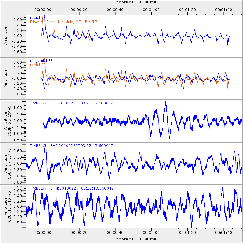
B21A Ellsworth Farm, Hinsdale, MT, USA - Earthquake Result Viewer
*The percent match for this event was below the threshold and hence no stack was calculated.
| Earthquake location: |
Near Coast Of Nicaragua |
| Earthquake latitude/longitude: |
11.2/-86.1 |
| Earthquake time(UTC): |
2010/02/25 (056) 03:15:03 GMT |
| Earthquake Depth: |
25 km |
| Earthquake Magnitude: |
5.6 MW, 5.3 MS, 5.4 MB, 5.6 MW |
| Earthquake Catalog/Contributor: |
WHDF/NEIC |
|
| Network: |
TA USArray Transportable Network (new EarthScope stations) |
| Station: |
B21A Ellsworth Farm, Hinsdale, MT, USA |
| Lat/Lon: |
48.43 N/107.02 W |
| Elevation: |
661 m |
|
| Distance: |
41.0 deg |
| Az: |
338.793 deg |
| Baz: |
147.796 deg |
| Ray Param: |
$rayparam |
*The percent match for this event was below the threshold and hence was not used in the summary stack. |
|
| Radial Match: |
71.84417 % |
| Radial Bump: |
322 |
| Transverse Match: |
51.35339 % |
| Transverse Bump: |
291 |
| SOD ConfigId: |
307546 |
| Insert Time: |
2010-05-14 07:58:42.381 +0000 |
| GWidth: |
2.5 |
| Max Bumps: |
400 |
| Tol: |
0.001 |
|
Signal To Noise
| Channel | StoN | STA | LTA |
| TA:B21A: :BHZ:20100225T03:22:13.60001Z | 4.213524 | 4.8171347E-7 | 1.1432555E-7 |
| TA:B21A: :BHN:20100225T03:22:13.60001Z | 1.4691893 | 3.4497762E-7 | 2.3480817E-7 |
| TA:B21A: :BHE:20100225T03:22:13.60001Z | 0.933428 | 1.8623912E-7 | 1.9952168E-7 |
| Arrivals |
| Ps | |
| PpPs | |
| PsPs/PpSs | |


