You are here: Home > Network List > IM - International Miscellaneous Stations Stations List
> Station MK31 Makanchi Array Site 31, Kazakhstan > Earthquake Result Viewer
MK31 Makanchi Array Site 31, Kazakhstan - Earthquake Result Viewer
| Earthquake location: |
Philippine Islands Region |
| Earthquake latitude/longitude: |
13.8/125.5 |
| Earthquake time(UTC): |
2023/04/04 (094) 12:54:32 GMT |
| Earthquake Depth: |
15 km |
| Earthquake Magnitude: |
6.2 mww |
| Earthquake Catalog/Contributor: |
NEIC PDE/us |
|
| Network: |
IM International Miscellaneous Stations |
| Station: |
MK31 Makanchi Array Site 31, Kazakhstan |
| Lat/Lon: |
46.79 N/82.29 E |
| Elevation: |
618 m |
|
| Distance: |
48.9 deg |
| Az: |
321.309 deg |
| Baz: |
117.861 deg |
| Ray Param: |
0.06907453 |
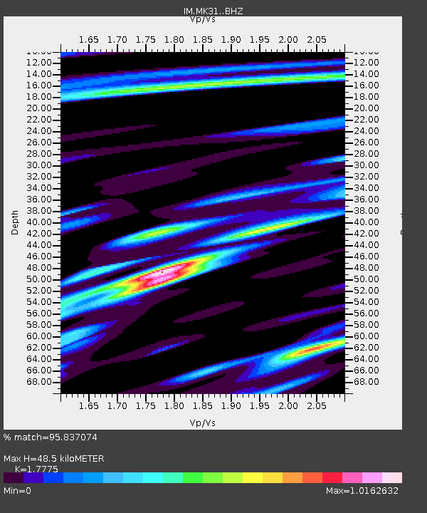
| Estimated Moho Depth: |
48.5 km |
| Estimated Crust Vp/Vs: |
1.78 |
| Assumed Crust Vp: |
6.688 km/s |
| Estimated Crust Vs: |
3.763 km/s |
| Estimated Crust Poisson's Ratio: |
0.27 |
|
| Radial Match: |
95.837074 % |
| Radial Bump: |
400 |
| Transverse Match: |
92.773346 % |
| Transverse Bump: |
400 |
| SOD ConfigId: |
30536071 |
| Insert Time: |
2023-04-18 13:06:05.202 +0000 |
| GWidth: |
2.5 |
| Max Bumps: |
400 |
| Tol: |
0.001 |
|

Signal To Noise
| Channel | StoN | STA | LTA |
| IM:MK31: :BHZ:20230404T13:02:46.498996Z | 13.853415 | 3.886319E-8 | 2.805315E-9 |
| IM:MK31: :BHN:20230404T13:02:46.498996Z | 3.7182326 | 1.0340228E-8 | 2.7809524E-9 |
| IM:MK31: :BHE:20230404T13:02:46.498996Z | 11.485377 | 2.216318E-8 | 1.9296866E-9 |
| Arrivals |
| Ps | 6.0 SECOND |
| PpPs | 19 SECOND |
| PsPs/PpSs | 25 SECOND |


