You are here: Home > Network List > TA - USArray Transportable Network (new EarthScope stations) Stations List
> Station E22A Miles City, MT, USA > Earthquake Result Viewer
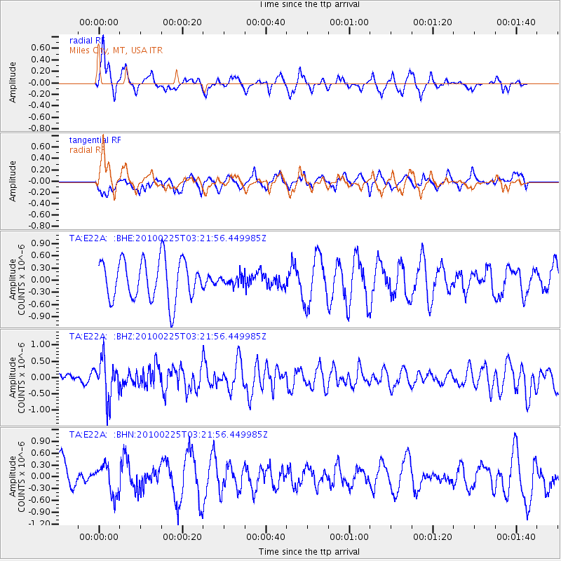
E22A Miles City, MT, USA - Earthquake Result Viewer
*The percent match for this event was below the threshold and hence no stack was calculated.
| Earthquake location: |
Near Coast Of Nicaragua |
| Earthquake latitude/longitude: |
11.2/-86.1 |
| Earthquake time(UTC): |
2010/02/25 (056) 03:15:03 GMT |
| Earthquake Depth: |
25 km |
| Earthquake Magnitude: |
5.6 MW, 5.3 MS, 5.4 MB, 5.6 MW |
| Earthquake Catalog/Contributor: |
WHDF/NEIC |
|
| Network: |
TA USArray Transportable Network (new EarthScope stations) |
| Station: |
E22A Miles City, MT, USA |
| Lat/Lon: |
46.44 N/105.95 W |
| Elevation: |
784 m |
|
| Distance: |
39.0 deg |
| Az: |
338.105 deg |
| Baz: |
148.053 deg |
| Ray Param: |
$rayparam |
*The percent match for this event was below the threshold and hence was not used in the summary stack. |
|
| Radial Match: |
65.508766 % |
| Radial Bump: |
351 |
| Transverse Match: |
43.444283 % |
| Transverse Bump: |
370 |
| SOD ConfigId: |
307546 |
| Insert Time: |
2010-05-14 08:00:48.912 +0000 |
| GWidth: |
2.5 |
| Max Bumps: |
400 |
| Tol: |
0.001 |
|
Signal To Noise
| Channel | StoN | STA | LTA |
| TA:E22A: :BHZ:20100225T03:21:56.449985Z | 3.0254653 | 5.963331E-7 | 1.971046E-7 |
| TA:E22A: :BHN:20100225T03:21:56.449985Z | 0.8326664 | 3.8184805E-7 | 4.5858465E-7 |
| TA:E22A: :BHE:20100225T03:21:56.449985Z | 0.2244685 | 1.1172961E-7 | 4.9775184E-7 |
| Arrivals |
| Ps | |
| PpPs | |
| PsPs/PpSs | |


