You are here: Home > Network List > TX - Texas Seismological Network Stations List
> Station FW07 Weatherford > Earthquake Result Viewer
FW07 Weatherford - Earthquake Result Viewer
| Earthquake location: |
Kuril Islands |
| Earthquake latitude/longitude: |
49.1/156.4 |
| Earthquake time(UTC): |
2018/10/10 (283) 23:16:04 GMT |
| Earthquake Depth: |
33 km |
| Earthquake Magnitude: |
6.8 Mi |
| Earthquake Catalog/Contributor: |
NEIC PDE/at |
|
| Network: |
TX Texas Seismological Network |
| Station: |
FW07 Weatherford |
| Lat/Lon: |
32.70 N/97.79 W |
| Elevation: |
311 m |
|
| Distance: |
75.3 deg |
| Az: |
57.012 deg |
| Baz: |
319.167 deg |
| Ray Param: |
0.051734146 |
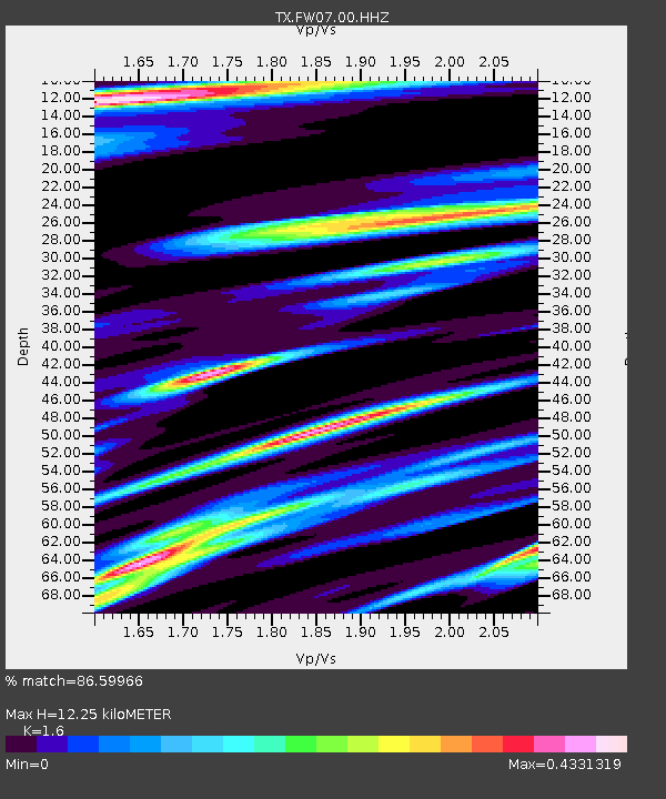
| Estimated Moho Depth: |
12.25 km |
| Estimated Crust Vp/Vs: |
1.60 |
| Assumed Crust Vp: |
6.38 km/s |
| Estimated Crust Vs: |
3.988 km/s |
| Estimated Crust Poisson's Ratio: |
0.18 |
|
| Radial Match: |
86.59966 % |
| Radial Bump: |
400 |
| Transverse Match: |
57.518353 % |
| Transverse Bump: |
375 |
| SOD ConfigId: |
3045211 |
| Insert Time: |
2018-10-24 23:31:26.616 +0000 |
| GWidth: |
2.5 |
| Max Bumps: |
400 |
| Tol: |
0.001 |
|

Signal To Noise
| Channel | StoN | STA | LTA |
| TX:FW07:00:HHZ:20181010T23:27:12.619995Z | 2.097326 | 8.265289E-7 | 3.9408698E-7 |
| TX:FW07:00:HH1:20181010T23:27:12.619995Z | 1.9172196 | 4.3481913E-7 | 2.2679673E-7 |
| TX:FW07:00:HH2:20181010T23:27:12.619995Z | 2.0048318 | 2.7216285E-7 | 1.3575345E-7 |
| Arrivals |
| Ps | 1.2 SECOND |
| PpPs | 4.8 SECOND |
| PsPs/PpSs | 6.0 SECOND |


