You are here: Home > Network List > TX - Texas Seismological Network Stations List
> Station FW13 Cleburne > Earthquake Result Viewer
FW13 Cleburne - Earthquake Result Viewer
| Earthquake location: |
Kuril Islands |
| Earthquake latitude/longitude: |
49.1/156.4 |
| Earthquake time(UTC): |
2018/10/10 (283) 23:16:04 GMT |
| Earthquake Depth: |
33 km |
| Earthquake Magnitude: |
6.8 Mi |
| Earthquake Catalog/Contributor: |
NEIC PDE/at |
|
| Network: |
TX Texas Seismological Network |
| Station: |
FW13 Cleburne |
| Lat/Lon: |
32.35 N/97.43 W |
| Elevation: |
259 m |
|
| Distance: |
75.7 deg |
| Az: |
57.013 deg |
| Baz: |
319.357 deg |
| Ray Param: |
0.051423058 |
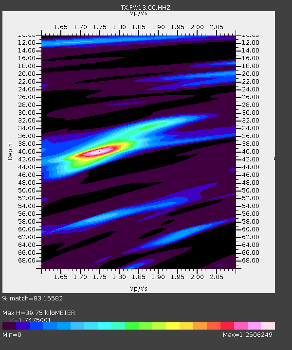
| Estimated Moho Depth: |
39.75 km |
| Estimated Crust Vp/Vs: |
1.75 |
| Assumed Crust Vp: |
6.38 km/s |
| Estimated Crust Vs: |
3.651 km/s |
| Estimated Crust Poisson's Ratio: |
0.26 |
|
| Radial Match: |
83.15582 % |
| Radial Bump: |
385 |
| Transverse Match: |
79.72768 % |
| Transverse Bump: |
399 |
| SOD ConfigId: |
3045211 |
| Insert Time: |
2018-10-24 23:31:32.034 +0000 |
| GWidth: |
2.5 |
| Max Bumps: |
400 |
| Tol: |
0.001 |
|

Signal To Noise
| Channel | StoN | STA | LTA |
| TX:FW13:00:HHZ:20181010T23:27:15.250Z | 2.3465261 | 9.2878474E-7 | 3.9581266E-7 |
| TX:FW13:00:HH1:20181010T23:27:15.250Z | 1.1401857 | 1.297204E-7 | 1.1377129E-7 |
| TX:FW13:00:HH2:20181010T23:27:15.250Z | 1.2098981 | 5.895068E-7 | 4.872367E-7 |
| Arrivals |
| Ps | 4.8 SECOND |
| PpPs | 17 SECOND |
| PsPs/PpSs | 21 SECOND |


