You are here: Home > Network List > TA - USArray Transportable Network (new EarthScope stations) Stations List
> Station I27A Quinn, SD, USA > Earthquake Result Viewer
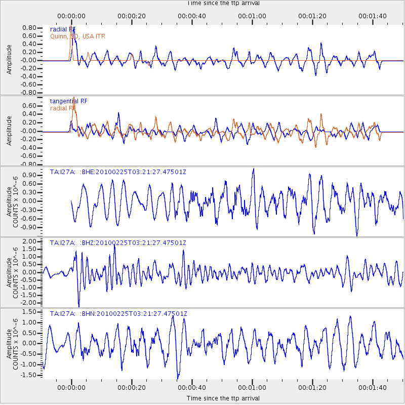
I27A Quinn, SD, USA - Earthquake Result Viewer
*The percent match for this event was below the threshold and hence no stack was calculated.
| Earthquake location: |
Near Coast Of Nicaragua |
| Earthquake latitude/longitude: |
11.2/-86.1 |
| Earthquake time(UTC): |
2010/02/25 (056) 03:15:03 GMT |
| Earthquake Depth: |
25 km |
| Earthquake Magnitude: |
5.6 MW, 5.3 MS, 5.4 MB, 5.6 MW |
| Earthquake Catalog/Contributor: |
WHDF/NEIC |
|
| Network: |
TA USArray Transportable Network (new EarthScope stations) |
| Station: |
I27A Quinn, SD, USA |
| Lat/Lon: |
44.07 N/102.05 W |
| Elevation: |
867 m |
|
| Distance: |
35.5 deg |
| Az: |
340.108 deg |
| Baz: |
152.407 deg |
| Ray Param: |
$rayparam |
*The percent match for this event was below the threshold and hence was not used in the summary stack. |
|
| Radial Match: |
63.736813 % |
| Radial Bump: |
370 |
| Transverse Match: |
69.47602 % |
| Transverse Bump: |
318 |
| SOD ConfigId: |
307546 |
| Insert Time: |
2010-05-14 08:05:46.894 +0000 |
| GWidth: |
2.5 |
| Max Bumps: |
400 |
| Tol: |
0.001 |
|
Signal To Noise
| Channel | StoN | STA | LTA |
| TA:I27A: :BHZ:20100225T03:21:27.47501Z | 6.221204 | 9.09526E-7 | 1.4619776E-7 |
| TA:I27A: :BHN:20100225T03:21:27.47501Z | 1.302432 | 4.955979E-7 | 3.805173E-7 |
| TA:I27A: :BHE:20100225T03:21:27.47501Z | 0.8891921 | 3.7427665E-7 | 4.2091767E-7 |
| Arrivals |
| Ps | |
| PpPs | |
| PsPs/PpSs | |


