You are here: Home > Network List > TX - Texas Seismological Network Stations List
> Station SN01 Snyder 1 > Earthquake Result Viewer
SN01 Snyder 1 - Earthquake Result Viewer
| Earthquake location: |
Kuril Islands |
| Earthquake latitude/longitude: |
49.1/156.4 |
| Earthquake time(UTC): |
2018/10/10 (283) 23:16:04 GMT |
| Earthquake Depth: |
33 km |
| Earthquake Magnitude: |
6.8 Mi |
| Earthquake Catalog/Contributor: |
NEIC PDE/at |
|
| Network: |
TX Texas Seismological Network |
| Station: |
SN01 Snyder 1 |
| Lat/Lon: |
32.86 N/100.89 W |
| Elevation: |
717 m |
|
| Distance: |
73.4 deg |
| Az: |
58.939 deg |
| Baz: |
318.014 deg |
| Ray Param: |
0.052965805 |
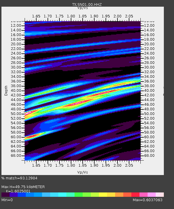
| Estimated Moho Depth: |
49.75 km |
| Estimated Crust Vp/Vs: |
1.60 |
| Assumed Crust Vp: |
6.426 km/s |
| Estimated Crust Vs: |
4.01 km/s |
| Estimated Crust Poisson's Ratio: |
0.18 |
|
| Radial Match: |
93.12984 % |
| Radial Bump: |
400 |
| Transverse Match: |
78.612724 % |
| Transverse Bump: |
400 |
| SOD ConfigId: |
3045211 |
| Insert Time: |
2018-10-24 23:32:03.556 +0000 |
| GWidth: |
2.5 |
| Max Bumps: |
400 |
| Tol: |
0.001 |
|
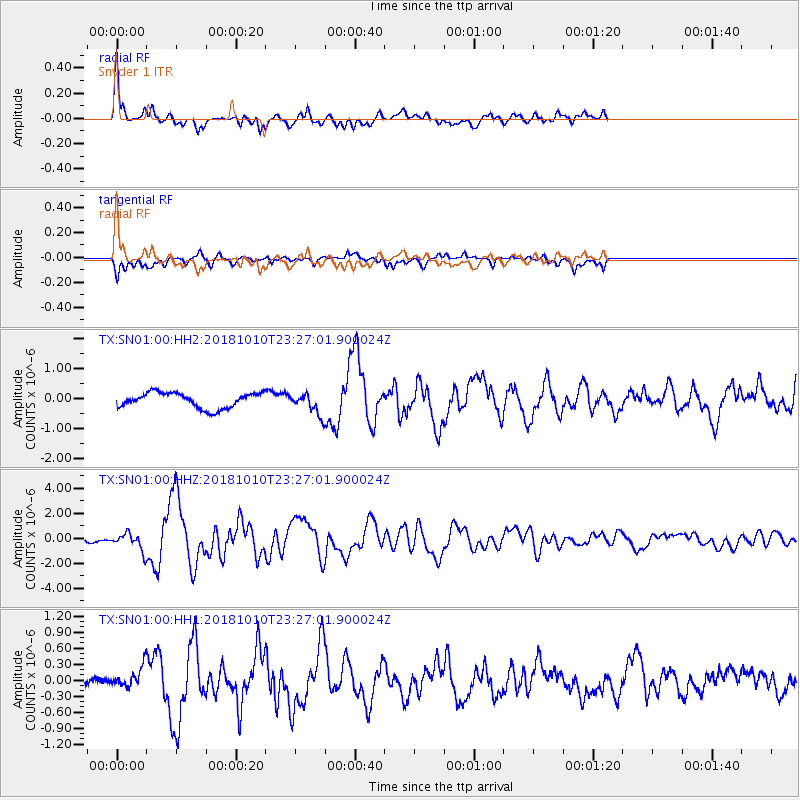
Signal To Noise
| Channel | StoN | STA | LTA |
| TX:SN01:00:HHZ:20181010T23:27:01.900024Z | 3.6117563 | 6.657745E-7 | 1.8433539E-7 |
| TX:SN01:00:HH1:20181010T23:27:01.900024Z | 1.5848799 | 1.8198834E-7 | 1.1482785E-7 |
| TX:SN01:00:HH2:20181010T23:27:01.900024Z | 1.3619885 | 3.4674557E-7 | 2.5458772E-7 |
| Arrivals |
| Ps | 4.8 SECOND |
| PpPs | 19 SECOND |
| PsPs/PpSs | 24 SECOND |


