You are here: Home > Network List > TA - USArray Transportable Network (new EarthScope stations) Stations List
> Station E29A Napoleon, ND, USA > Earthquake Result Viewer
E29A Napoleon, ND, USA - Earthquake Result Viewer
| Earthquake location: |
Near Coast Of Nicaragua |
| Earthquake latitude/longitude: |
11.2/-86.1 |
| Earthquake time(UTC): |
2010/02/25 (056) 03:15:03 GMT |
| Earthquake Depth: |
25 km |
| Earthquake Magnitude: |
5.6 MW, 5.3 MS, 5.4 MB, 5.6 MW |
| Earthquake Catalog/Contributor: |
WHDF/NEIC |
|
| Network: |
TA USArray Transportable Network (new EarthScope stations) |
| Station: |
E29A Napoleon, ND, USA |
| Lat/Lon: |
46.57 N/99.64 W |
| Elevation: |
628 m |
|
| Distance: |
37.1 deg |
| Az: |
344.493 deg |
| Baz: |
157.65 deg |
| Ray Param: |
0.076285824 |
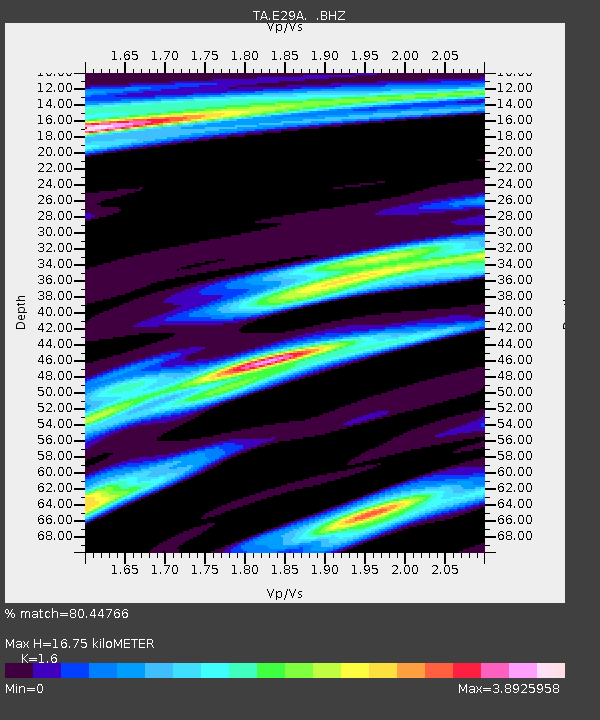
| Estimated Moho Depth: |
16.75 km |
| Estimated Crust Vp/Vs: |
1.60 |
| Assumed Crust Vp: |
6.53 km/s |
| Estimated Crust Vs: |
4.082 km/s |
| Estimated Crust Poisson's Ratio: |
0.18 |
|
| Radial Match: |
80.44766 % |
| Radial Bump: |
367 |
| Transverse Match: |
42.37575 % |
| Transverse Bump: |
392 |
| SOD ConfigId: |
307546 |
| Insert Time: |
2010-05-14 08:08:51.120 +0000 |
| GWidth: |
2.5 |
| Max Bumps: |
400 |
| Tol: |
0.001 |
|

Signal To Noise
| Channel | StoN | STA | LTA |
| TA:E29A: :BHZ:20100225T03:21:40.674991Z | 4.546809 | 9.169344E-7 | 2.0166546E-7 |
| TA:E29A: :BHN:20100225T03:21:40.674991Z | 1.4008684 | 8.8752824E-7 | 6.3355577E-7 |
| TA:E29A: :BHE:20100225T03:21:40.674991Z | 1.0255401 | 6.9070785E-7 | 6.735064E-7 |
| Arrivals |
| Ps | 1.7 SECOND |
| PpPs | 6.1 SECOND |
| PsPs/PpSs | 7.8 SECOND |


