You are here: Home > Network List > TA - USArray Transportable Network (new EarthScope stations) Stations List
> Station F28A McLaughlin, SD, USA > Earthquake Result Viewer
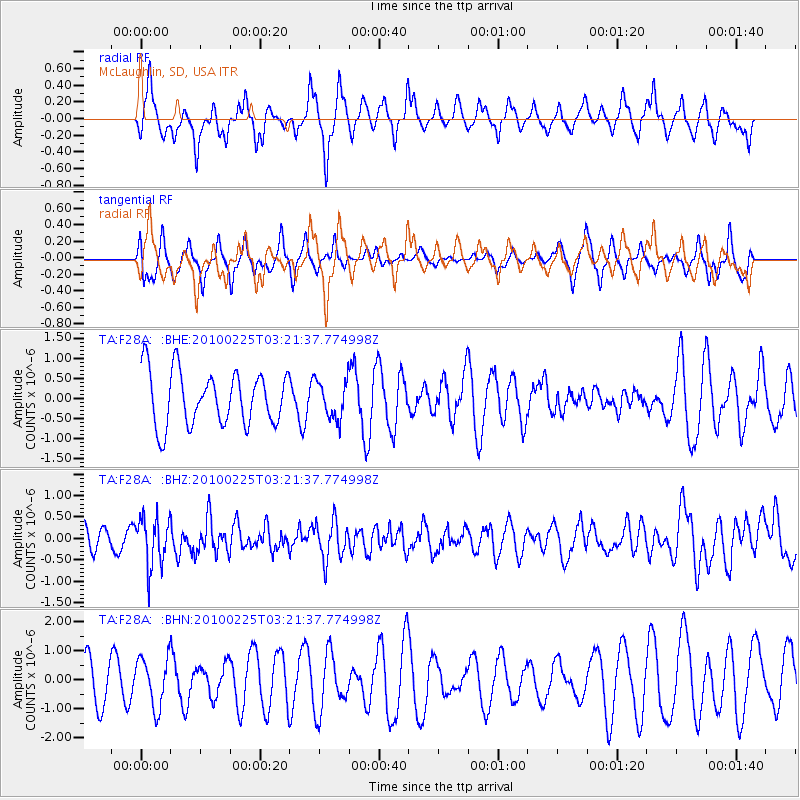
F28A McLaughlin, SD, USA - Earthquake Result Viewer
*The percent match for this event was below the threshold and hence no stack was calculated.
| Earthquake location: |
Near Coast Of Nicaragua |
| Earthquake latitude/longitude: |
11.2/-86.1 |
| Earthquake time(UTC): |
2010/02/25 (056) 03:15:03 GMT |
| Earthquake Depth: |
25 km |
| Earthquake Magnitude: |
5.6 MW, 5.3 MS, 5.4 MB, 5.6 MW |
| Earthquake Catalog/Contributor: |
WHDF/NEIC |
|
| Network: |
TA USArray Transportable Network (new EarthScope stations) |
| Station: |
F28A McLaughlin, SD, USA |
| Lat/Lon: |
45.85 N/100.80 W |
| Elevation: |
633 m |
|
| Distance: |
36.8 deg |
| Az: |
342.787 deg |
| Baz: |
155.453 deg |
| Ray Param: |
$rayparam |
*The percent match for this event was below the threshold and hence was not used in the summary stack. |
|
| Radial Match: |
56.226826 % |
| Radial Bump: |
324 |
| Transverse Match: |
49.430553 % |
| Transverse Bump: |
338 |
| SOD ConfigId: |
307546 |
| Insert Time: |
2010-05-14 08:09:17.541 +0000 |
| GWidth: |
2.5 |
| Max Bumps: |
400 |
| Tol: |
0.001 |
|
Signal To Noise
| Channel | StoN | STA | LTA |
| TA:F28A: :BHZ:20100225T03:21:37.774998Z | 2.2953563 | 5.703346E-7 | 2.4847324E-7 |
| TA:F28A: :BHN:20100225T03:21:37.774998Z | 1.1245642 | 8.472501E-7 | 7.53403E-7 |
| TA:F28A: :BHE:20100225T03:21:37.774998Z | 0.71773577 | 4.771946E-7 | 6.6486115E-7 |
| Arrivals |
| Ps | |
| PpPs | |
| PsPs/PpSs | |


