You are here: Home > Network List > TA - USArray Transportable Network (new EarthScope stations) Stations List
> Station J29A Okreek, SD, USA > Earthquake Result Viewer
J29A Okreek, SD, USA - Earthquake Result Viewer
| Earthquake location: |
Near Coast Of Nicaragua |
| Earthquake latitude/longitude: |
11.2/-86.1 |
| Earthquake time(UTC): |
2010/02/25 (056) 03:15:03 GMT |
| Earthquake Depth: |
25 km |
| Earthquake Magnitude: |
5.6 MW, 5.3 MS, 5.4 MB, 5.6 MW |
| Earthquake Catalog/Contributor: |
WHDF/NEIC |
|
| Network: |
TA USArray Transportable Network (new EarthScope stations) |
| Station: |
J29A Okreek, SD, USA |
| Lat/Lon: |
43.41 N/100.33 W |
| Elevation: |
644 m |
|
| Distance: |
34.4 deg |
| Az: |
341.55 deg |
| Baz: |
154.779 deg |
| Ray Param: |
0.07772728 |
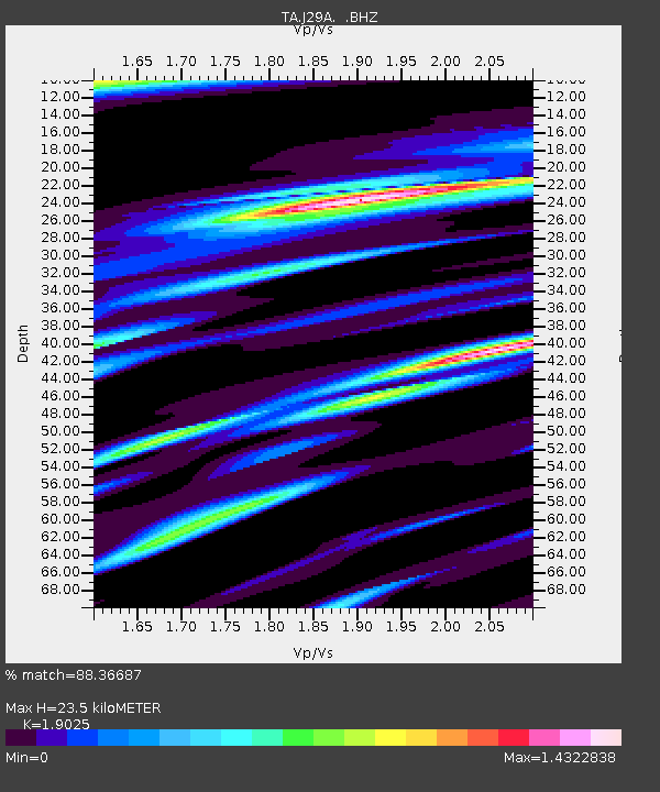
| Estimated Moho Depth: |
23.5 km |
| Estimated Crust Vp/Vs: |
1.90 |
| Assumed Crust Vp: |
6.483 km/s |
| Estimated Crust Vs: |
3.407 km/s |
| Estimated Crust Poisson's Ratio: |
0.31 |
|
| Radial Match: |
88.36687 % |
| Radial Bump: |
376 |
| Transverse Match: |
50.290302 % |
| Transverse Bump: |
400 |
| SOD ConfigId: |
307546 |
| Insert Time: |
2010-05-14 08:10:29.184 +0000 |
| GWidth: |
2.5 |
| Max Bumps: |
400 |
| Tol: |
0.001 |
|

Signal To Noise
| Channel | StoN | STA | LTA |
| TA:J29A: :BHZ:20100225T03:21:17.574985Z | 6.3706717 | 7.873923E-7 | 1.2359644E-7 |
| TA:J29A: :BHN:20100225T03:21:17.574985Z | 3.5702183 | 6.8362016E-7 | 1.9147853E-7 |
| TA:J29A: :BHE:20100225T03:21:17.574985Z | 2.512623 | 6.79916E-7 | 2.706001E-7 |
| Arrivals |
| Ps | 3.5 SECOND |
| PpPs | 9.8 SECOND |
| PsPs/PpSs | 13 SECOND |


