You are here: Home > Network List > TA - USArray Transportable Network (new EarthScope stations) Stations List
> Station P32A Huiting Farm, Downs, KS, USA > Earthquake Result Viewer
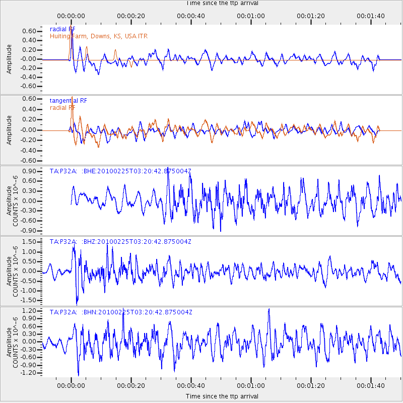
P32A Huiting Farm, Downs, KS, USA - Earthquake Result Viewer
*The percent match for this event was below the threshold and hence no stack was calculated.
| Earthquake location: |
Near Coast Of Nicaragua |
| Earthquake latitude/longitude: |
11.2/-86.1 |
| Earthquake time(UTC): |
2010/02/25 (056) 03:15:03 GMT |
| Earthquake Depth: |
25 km |
| Earthquake Magnitude: |
5.6 MW, 5.3 MS, 5.4 MB, 5.6 MW |
| Earthquake Catalog/Contributor: |
WHDF/NEIC |
|
| Network: |
TA USArray Transportable Network (new EarthScope stations) |
| Station: |
P32A Huiting Farm, Downs, KS, USA |
| Lat/Lon: |
39.62 N/98.60 W |
| Elevation: |
524 m |
|
| Distance: |
30.4 deg |
| Az: |
340.761 deg |
| Baz: |
155.252 deg |
| Ray Param: |
$rayparam |
*The percent match for this event was below the threshold and hence was not used in the summary stack. |
|
| Radial Match: |
65.454544 % |
| Radial Bump: |
400 |
| Transverse Match: |
49.682453 % |
| Transverse Bump: |
398 |
| SOD ConfigId: |
307546 |
| Insert Time: |
2010-05-14 08:10:41.285 +0000 |
| GWidth: |
2.5 |
| Max Bumps: |
400 |
| Tol: |
0.001 |
|
Signal To Noise
| Channel | StoN | STA | LTA |
| TA:P32A: :BHZ:20100225T03:20:42.875004Z | 4.4278507 | 8.117296E-7 | 1.833236E-7 |
| TA:P32A: :BHN:20100225T03:20:42.875004Z | 2.0590386 | 4.875663E-7 | 2.3679318E-7 |
| TA:P32A: :BHE:20100225T03:20:42.875004Z | 2.077493 | 4.1898588E-7 | 2.0167859E-7 |
| Arrivals |
| Ps | |
| PpPs | |
| PsPs/PpSs | |


