You are here: Home > Network List > US - United States National Seismic Network Stations List
> Station WUAZ Wupatki, Arizona, USA > Earthquake Result Viewer
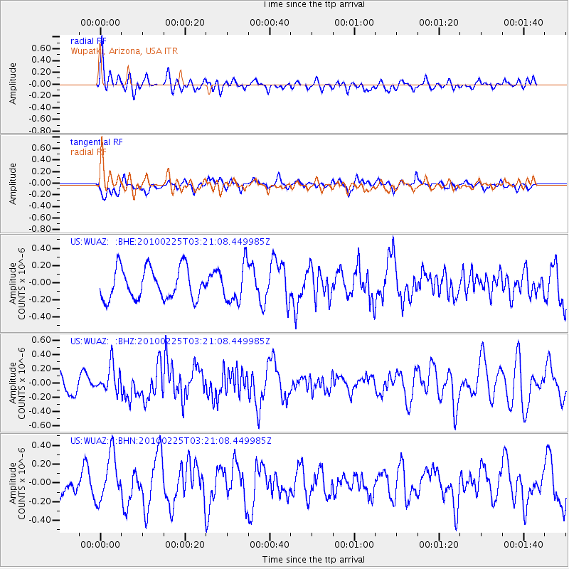
WUAZ Wupatki, Arizona, USA - Earthquake Result Viewer
*The percent match for this event was below the threshold and hence no stack was calculated.
| Earthquake location: |
Near Coast Of Nicaragua |
| Earthquake latitude/longitude: |
11.2/-86.1 |
| Earthquake time(UTC): |
2010/02/25 (056) 03:15:03 GMT |
| Earthquake Depth: |
25 km |
| Earthquake Magnitude: |
5.6 MW, 5.3 MS, 5.4 MB, 5.6 MW |
| Earthquake Catalog/Contributor: |
WHDF/NEIC |
|
| Network: |
US United States National Seismic Network |
| Station: |
WUAZ Wupatki, Arizona, USA |
| Lat/Lon: |
35.52 N/111.37 W |
| Elevation: |
1592 m |
|
| Distance: |
33.3 deg |
| Az: |
320.721 deg |
| Baz: |
130.4 deg |
| Ray Param: |
$rayparam |
*The percent match for this event was below the threshold and hence was not used in the summary stack. |
|
| Radial Match: |
62.380383 % |
| Radial Bump: |
400 |
| Transverse Match: |
62.16851 % |
| Transverse Bump: |
400 |
| SOD ConfigId: |
307546 |
| Insert Time: |
2010-05-14 08:12:15.305 +0000 |
| GWidth: |
2.5 |
| Max Bumps: |
400 |
| Tol: |
0.001 |
|
Signal To Noise
| Channel | StoN | STA | LTA |
| US:WUAZ: :BHZ:20100225T03:21:08.449985Z | 0.87158114 | 1.9998751E-7 | 2.294537E-7 |
| US:WUAZ: :BHN:20100225T03:21:08.449985Z | 2.9328222 | 2.5742813E-7 | 8.7774886E-8 |
| US:WUAZ: :BHE:20100225T03:21:08.449985Z | 1.2477782 | 2.216537E-7 | 1.7763871E-7 |
| Arrivals |
| Ps | |
| PpPs | |
| PsPs/PpSs | |


