You are here: Home > Network List > US - United States National Seismic Network Stations List
> Station ERPA Erie, Pennsylvania, USA > Earthquake Result Viewer
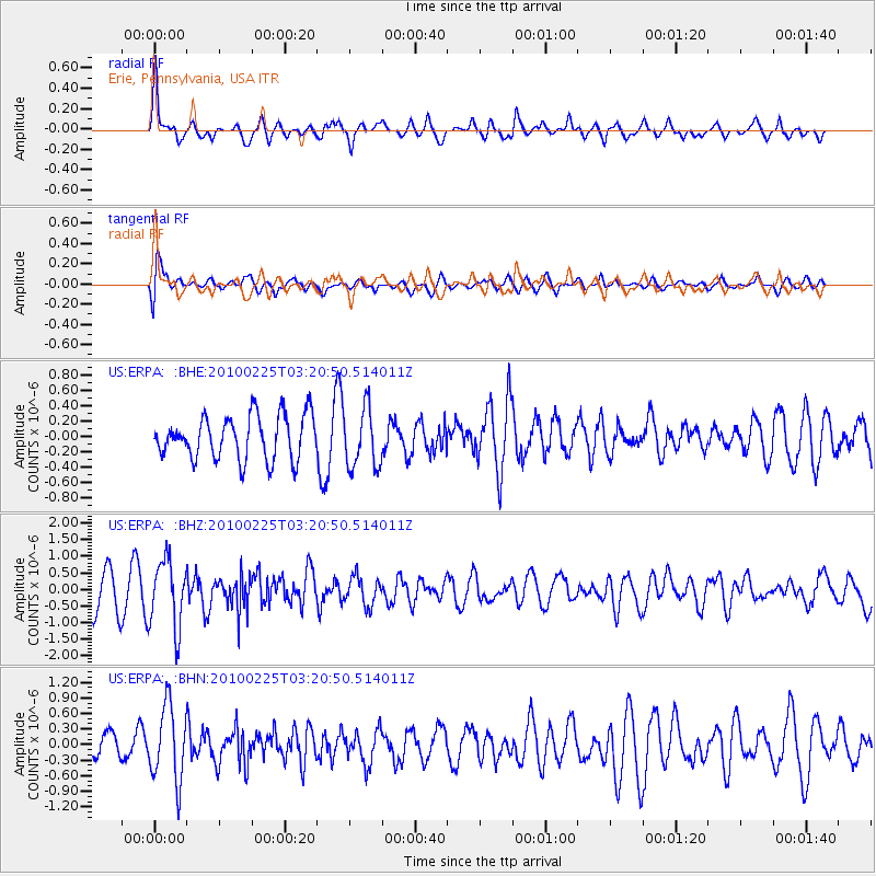
ERPA Erie, Pennsylvania, USA - Earthquake Result Viewer
*The percent match for this event was below the threshold and hence no stack was calculated.
| Earthquake location: |
Near Coast Of Nicaragua |
| Earthquake latitude/longitude: |
11.2/-86.1 |
| Earthquake time(UTC): |
2010/02/25 (056) 03:15:03 GMT |
| Earthquake Depth: |
25 km |
| Earthquake Magnitude: |
5.6 MW, 5.3 MS, 5.4 MB, 5.6 MW |
| Earthquake Catalog/Contributor: |
WHDF/NEIC |
|
| Network: |
US United States National Seismic Network |
| Station: |
ERPA Erie, Pennsylvania, USA |
| Lat/Lon: |
42.12 N/79.99 W |
| Elevation: |
306 m |
|
| Distance: |
31.3 deg |
| Az: |
8.81 deg |
| Baz: |
191.654 deg |
| Ray Param: |
$rayparam |
*The percent match for this event was below the threshold and hence was not used in the summary stack. |
|
| Radial Match: |
65.10798 % |
| Radial Bump: |
375 |
| Transverse Match: |
67.55335 % |
| Transverse Bump: |
400 |
| SOD ConfigId: |
307546 |
| Insert Time: |
2010-05-14 08:12:39.515 +0000 |
| GWidth: |
2.5 |
| Max Bumps: |
400 |
| Tol: |
0.001 |
|
Signal To Noise
| Channel | StoN | STA | LTA |
| US:ERPA: :BHZ:20100225T03:20:50.514011Z | 2.1451628 | 1.0227515E-6 | 4.7677102E-7 |
| US:ERPA: :BHN:20100225T03:20:50.514011Z | 2.9167523 | 7.1737657E-7 | 2.4595047E-7 |
| US:ERPA: :BHE:20100225T03:20:50.514011Z | 1.3789291 | 3.8955616E-7 | 2.8250628E-7 |
| Arrivals |
| Ps | |
| PpPs | |
| PsPs/PpSs | |


