You are here: Home > Network List > US - United States National Seismic Network Stations List
> Station AGMN Agassiz National Wildlife Refuge, Minnesota, USA > Earthquake Result Viewer
AGMN Agassiz National Wildlife Refuge, Minnesota, USA - Earthquake Result Viewer
*The percent match for this event was below the threshold and hence no stack was calculated.
| Earthquake location: |
Near Coast Of Nicaragua |
| Earthquake latitude/longitude: |
11.2/-86.1 |
| Earthquake time(UTC): |
2010/02/25 (056) 03:15:03 GMT |
| Earthquake Depth: |
25 km |
| Earthquake Magnitude: |
5.6 MW, 5.3 MS, 5.4 MB, 5.6 MW |
| Earthquake Catalog/Contributor: |
WHDF/NEIC |
|
| Network: |
US United States National Seismic Network |
| Station: |
AGMN Agassiz National Wildlife Refuge, Minnesota, USA |
| Lat/Lon: |
48.30 N/95.86 W |
| Elevation: |
351 m |
|
| Distance: |
37.9 deg |
| Az: |
349.406 deg |
| Baz: |
164.325 deg |
| Ray Param: |
$rayparam |
*The percent match for this event was below the threshold and hence was not used in the summary stack. |
|
| Radial Match: |
73.354195 % |
| Radial Bump: |
224 |
| Transverse Match: |
57.799465 % |
| Transverse Bump: |
377 |
| SOD ConfigId: |
307546 |
| Insert Time: |
2010-05-14 08:13:25.090 +0000 |
| GWidth: |
2.5 |
| Max Bumps: |
400 |
| Tol: |
0.001 |
|
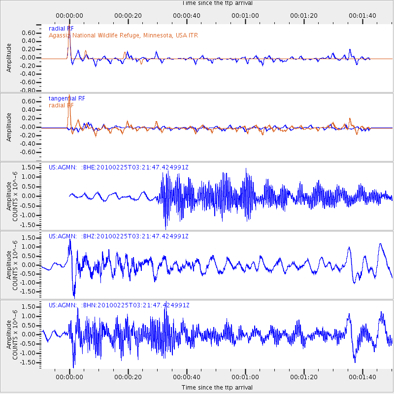
Signal To Noise
| Channel | StoN | STA | LTA |
| US:AGMN: :BHZ:20100225T03:21:47.424991Z | 4.4154053 | 8.0201033E-7 | 1.8163912E-7 |
| US:AGMN: :BHN:20100225T03:21:47.424991Z | 4.924144 | 6.623754E-7 | 1.3451586E-7 |
| US:AGMN: :BHE:20100225T03:21:47.424991Z | 5.5349956 | 6.217435E-7 | 1.1232953E-7 |
| Arrivals |
| Ps | |
| PpPs | |
| PsPs/PpSs | |


