You are here: Home > Network List > C0 - Colorado Geological Survey Seismic Network Stations List
> Station CHIL CSU-CHILL Radar > Earthquake Result Viewer
CHIL CSU-CHILL Radar - Earthquake Result Viewer
| Earthquake location: |
South Of Panama |
| Earthquake latitude/longitude: |
7.6/-82.3 |
| Earthquake time(UTC): |
2023/04/04 (094) 22:18:12 GMT |
| Earthquake Depth: |
10 km |
| Earthquake Magnitude: |
6.3 mww |
| Earthquake Catalog/Contributor: |
NEIC PDE/at |
|
| Network: |
C0 Colorado Geological Survey Seismic Network |
| Station: |
CHIL CSU-CHILL Radar |
| Lat/Lon: |
40.45 N/104.64 W |
| Elevation: |
1424 m |
|
| Distance: |
38.3 deg |
| Az: |
332.137 deg |
| Baz: |
142.618 deg |
| Ray Param: |
0.07565296 |
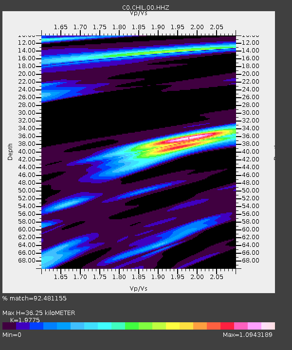
| Estimated Moho Depth: |
36.25 km |
| Estimated Crust Vp/Vs: |
1.98 |
| Assumed Crust Vp: |
6.306 km/s |
| Estimated Crust Vs: |
3.189 km/s |
| Estimated Crust Poisson's Ratio: |
0.33 |
|
| Radial Match: |
92.481155 % |
| Radial Bump: |
295 |
| Transverse Match: |
62.461796 % |
| Transverse Bump: |
400 |
| SOD ConfigId: |
30536071 |
| Insert Time: |
2023-04-18 22:29:41.040 +0000 |
| GWidth: |
2.5 |
| Max Bumps: |
400 |
| Tol: |
0.001 |
|

Signal To Noise
| Channel | StoN | STA | LTA |
| C0:CHIL:00:HHZ:20230404T22:25:01.95401Z | 14.474464 | 2.4713172E-6 | 1.7073636E-7 |
| C0:CHIL:00:HHN:20230404T22:25:01.95401Z | 3.4899242 | 7.922782E-7 | 2.2701873E-7 |
| C0:CHIL:00:HHE:20230404T22:25:01.95401Z | 1.7381804 | 6.728396E-7 | 3.8709422E-7 |
| Arrivals |
| Ps | 6.0 SECOND |
| PpPs | 16 SECOND |
| PsPs/PpSs | 22 SECOND |


