You are here: Home > Network List > CC - Cascade Chain Volcano Monitoring Stations List
> Station MILD Mildred Point > Earthquake Result Viewer
MILD Mildred Point - Earthquake Result Viewer
| Earthquake location: |
South Of Panama |
| Earthquake latitude/longitude: |
7.6/-82.3 |
| Earthquake time(UTC): |
2023/04/04 (094) 22:18:12 GMT |
| Earthquake Depth: |
10 km |
| Earthquake Magnitude: |
6.3 mww |
| Earthquake Catalog/Contributor: |
NEIC PDE/at |
|
| Network: |
CC Cascade Chain Volcano Monitoring |
| Station: |
MILD Mildred Point |
| Lat/Lon: |
46.81 N/121.78 W |
| Elevation: |
2016 m |
|
| Distance: |
51.6 deg |
| Az: |
326.16 deg |
| Baz: |
126.512 deg |
| Ray Param: |
0.06730476 |
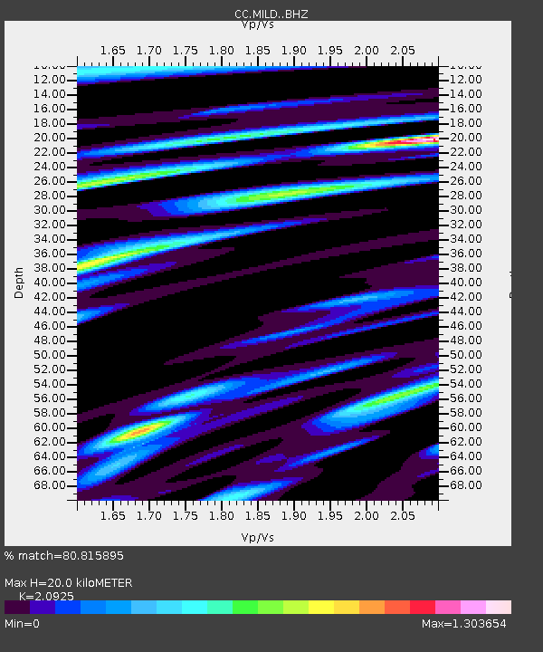
| Estimated Moho Depth: |
20.0 km |
| Estimated Crust Vp/Vs: |
2.09 |
| Assumed Crust Vp: |
6.597 km/s |
| Estimated Crust Vs: |
3.153 km/s |
| Estimated Crust Poisson's Ratio: |
0.35 |
|
| Radial Match: |
80.815895 % |
| Radial Bump: |
400 |
| Transverse Match: |
63.401165 % |
| Transverse Bump: |
400 |
| SOD ConfigId: |
30536071 |
| Insert Time: |
2023-04-18 22:31:06.966 +0000 |
| GWidth: |
2.5 |
| Max Bumps: |
400 |
| Tol: |
0.001 |
|

Signal To Noise
| Channel | StoN | STA | LTA |
| CC:MILD: :BHZ:20230404T22:26:47.52002Z | 12.590401 | 1.7793855E-6 | 1.4132874E-7 |
| CC:MILD: :BHN:20230404T22:26:47.52002Z | 5.9377713 | 8.347016E-7 | 1.4057491E-7 |
| CC:MILD: :BHE:20230404T22:26:47.52002Z | 2.8575952 | 6.4574425E-7 | 2.2597472E-7 |
| Arrivals |
| Ps | 3.5 SECOND |
| PpPs | 8.9 SECOND |
| PsPs/PpSs | 12 SECOND |


