You are here: Home > Network List > CI - Caltech Regional Seismic Network Stations List
> Station SWS Sam W. Stewart, Westmorland, CA, USA > Earthquake Result Viewer
SWS Sam W. Stewart, Westmorland, CA, USA - Earthquake Result Viewer
| Earthquake location: |
South Of Panama |
| Earthquake latitude/longitude: |
7.6/-82.3 |
| Earthquake time(UTC): |
2023/04/04 (094) 22:18:12 GMT |
| Earthquake Depth: |
10 km |
| Earthquake Magnitude: |
6.3 mww |
| Earthquake Catalog/Contributor: |
NEIC PDE/at |
|
| Network: |
CI Caltech Regional Seismic Network |
| Station: |
SWS Sam W. Stewart, Westmorland, CA, USA |
| Lat/Lon: |
32.94 N/115.80 W |
| Elevation: |
140 m |
|
| Distance: |
40.0 deg |
| Az: |
313.794 deg |
| Baz: |
121.677 deg |
| Ray Param: |
0.07466171 |
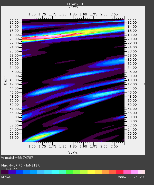
| Estimated Moho Depth: |
17.75 km |
| Estimated Crust Vp/Vs: |
1.77 |
| Assumed Crust Vp: |
6.155 km/s |
| Estimated Crust Vs: |
3.477 km/s |
| Estimated Crust Poisson's Ratio: |
0.27 |
|
| Radial Match: |
85.74787 % |
| Radial Bump: |
400 |
| Transverse Match: |
81.892784 % |
| Transverse Bump: |
400 |
| SOD ConfigId: |
30536071 |
| Insert Time: |
2023-04-18 22:33:31.425 +0000 |
| GWidth: |
2.5 |
| Max Bumps: |
400 |
| Tol: |
0.001 |
|
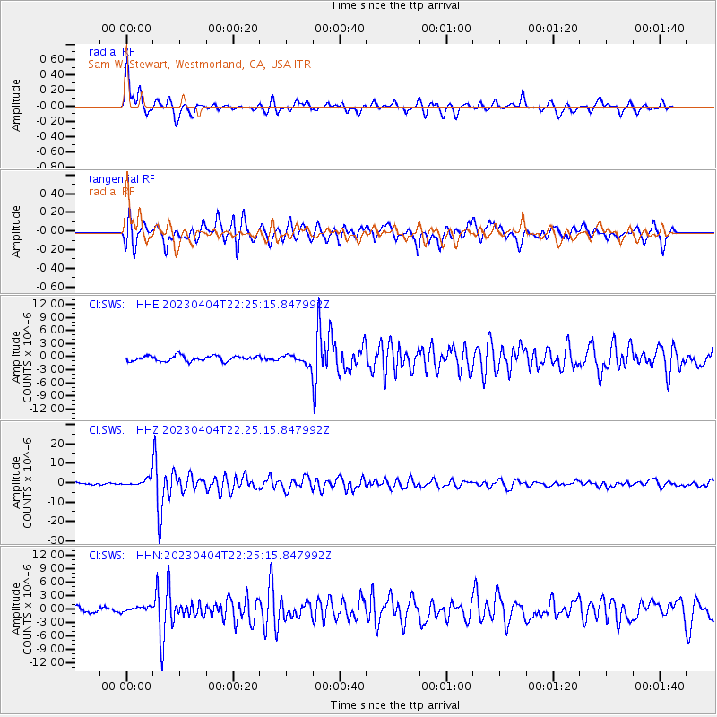
Signal To Noise
| Channel | StoN | STA | LTA |
| CI:SWS: :HHZ:20230404T22:25:15.847992Z | 4.3336563 | 2.0729738E-6 | 4.7834294E-7 |
| CI:SWS: :HHN:20230404T22:25:15.847992Z | 1.265736 | 6.4764237E-7 | 5.1167257E-7 |
| CI:SWS: :HHE:20230404T22:25:15.847992Z | 1.801729 | 1.1077711E-6 | 6.1483786E-7 |
| Arrivals |
| Ps | 2.4 SECOND |
| PpPs | 7.5 SECOND |
| PsPs/PpSs | 9.9 SECOND |


