You are here: Home > Network List > N4 - Central and EAstern US Network Stations List
> Station R49A Shelbyville, KY, USA > Earthquake Result Viewer
R49A Shelbyville, KY, USA - Earthquake Result Viewer
| Earthquake location: |
South Of Panama |
| Earthquake latitude/longitude: |
7.6/-82.3 |
| Earthquake time(UTC): |
2023/04/04 (094) 22:18:12 GMT |
| Earthquake Depth: |
10 km |
| Earthquake Magnitude: |
6.3 mww |
| Earthquake Catalog/Contributor: |
NEIC PDE/at |
|
| Network: |
N4 Central and EAstern US Network |
| Station: |
R49A Shelbyville, KY, USA |
| Lat/Lon: |
38.29 N/85.17 W |
| Elevation: |
251 m |
|
| Distance: |
30.7 deg |
| Az: |
355.603 deg |
| Baz: |
174.457 deg |
| Ray Param: |
0.07934319 |
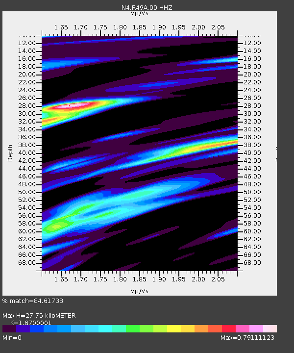
| Estimated Moho Depth: |
27.75 km |
| Estimated Crust Vp/Vs: |
1.67 |
| Assumed Crust Vp: |
6.498 km/s |
| Estimated Crust Vs: |
3.891 km/s |
| Estimated Crust Poisson's Ratio: |
0.22 |
|
| Radial Match: |
84.61738 % |
| Radial Bump: |
315 |
| Transverse Match: |
70.03157 % |
| Transverse Bump: |
390 |
| SOD ConfigId: |
30536071 |
| Insert Time: |
2023-04-18 22:42:29.645 +0000 |
| GWidth: |
2.5 |
| Max Bumps: |
400 |
| Tol: |
0.001 |
|

Signal To Noise
| Channel | StoN | STA | LTA |
| N4:R49A:00:HHZ:20230404T22:23:56.119995Z | 5.467012 | 1.4881202E-6 | 2.7219994E-7 |
| N4:R49A:00:HH1:20230404T22:23:56.119995Z | 5.9953647 | 1.1252239E-6 | 1.8768232E-7 |
| N4:R49A:00:HH2:20230404T22:23:56.119995Z | 1.1691049 | 2.0262094E-7 | 1.7331288E-7 |
| Arrivals |
| Ps | 3.1 SECOND |
| PpPs | 10 SECOND |
| PsPs/PpSs | 14 SECOND |


