You are here: Home > Network List > O2 - Oklahoma Consolidated Temporary Seismic Networks Stations List
> Station PERK Perkins, Oklahoma, USA > Earthquake Result Viewer
PERK Perkins, Oklahoma, USA - Earthquake Result Viewer
| Earthquake location: |
South Of Panama |
| Earthquake latitude/longitude: |
7.6/-82.3 |
| Earthquake time(UTC): |
2023/04/04 (094) 22:18:12 GMT |
| Earthquake Depth: |
10 km |
| Earthquake Magnitude: |
6.3 mww |
| Earthquake Catalog/Contributor: |
NEIC PDE/at |
|
| Network: |
O2 Oklahoma Consolidated Temporary Seismic Networks |
| Station: |
PERK Perkins, Oklahoma, USA |
| Lat/Lon: |
35.93 N/97.13 W |
| Elevation: |
288 m |
|
| Distance: |
31.3 deg |
| Az: |
336.468 deg |
| Baz: |
150.812 deg |
| Ray Param: |
0.079126276 |
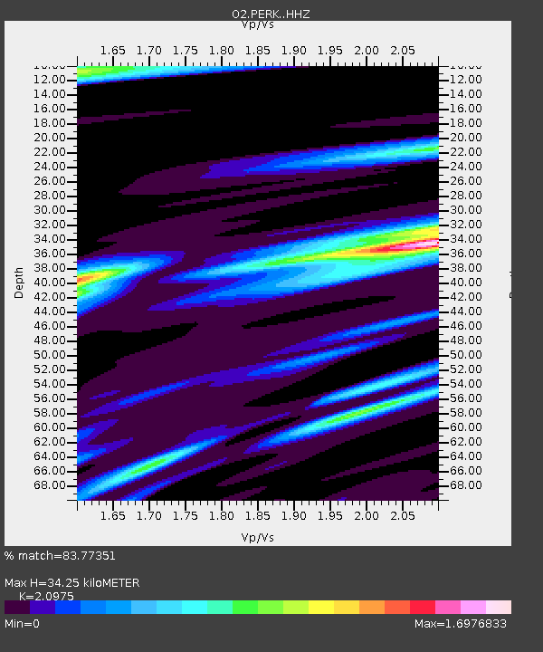
| Estimated Moho Depth: |
34.25 km |
| Estimated Crust Vp/Vs: |
2.10 |
| Assumed Crust Vp: |
6.426 km/s |
| Estimated Crust Vs: |
3.064 km/s |
| Estimated Crust Poisson's Ratio: |
0.35 |
|
| Radial Match: |
83.77351 % |
| Radial Bump: |
400 |
| Transverse Match: |
74.99306 % |
| Transverse Bump: |
400 |
| SOD ConfigId: |
30536071 |
| Insert Time: |
2023-04-18 22:44:51.729 +0000 |
| GWidth: |
2.5 |
| Max Bumps: |
400 |
| Tol: |
0.001 |
|

Signal To Noise
| Channel | StoN | STA | LTA |
| O2:PERK: :HHZ:20230404T22:24:01.535004Z | 10.323484 | 2.399879E-6 | 2.3246791E-7 |
| O2:PERK: :HHN:20230404T22:24:01.535004Z | 2.312327 | 1.1509978E-6 | 4.9776605E-7 |
| O2:PERK: :HHE:20230404T22:24:01.535004Z | 1.7953622 | 6.079885E-7 | 3.386439E-7 |
| Arrivals |
| Ps | 6.3 SECOND |
| PpPs | 15 SECOND |
| PsPs/PpSs | 22 SECOND |


