You are here: Home > Network List > GS - US Geological Survey Networks Stations List
> Station DEC06 Boomer > Earthquake Result Viewer
DEC06 Boomer - Earthquake Result Viewer
*The percent match for this event was below the threshold and hence no stack was calculated.
| Earthquake location: |
Kuril Islands |
| Earthquake latitude/longitude: |
49.2/156.3 |
| Earthquake time(UTC): |
2018/10/10 (283) 23:21:50 GMT |
| Earthquake Depth: |
10 km |
| Earthquake Magnitude: |
5.5 mb |
| Earthquake Catalog/Contributor: |
NEIC PDE/us |
|
| Network: |
GS US Geological Survey Networks |
| Station: |
DEC06 Boomer |
| Lat/Lon: |
39.90 N/88.95 W |
| Elevation: |
215 m |
|
| Distance: |
74.3 deg |
| Az: |
46.521 deg |
| Baz: |
321.78 deg |
| Ray Param: |
$rayparam |
*The percent match for this event was below the threshold and hence was not used in the summary stack. |
|
| Radial Match: |
62.431183 % |
| Radial Bump: |
400 |
| Transverse Match: |
57.847164 % |
| Transverse Bump: |
400 |
| SOD ConfigId: |
3045211 |
| Insert Time: |
2018-10-25 03:23:19.483 +0000 |
| GWidth: |
2.5 |
| Max Bumps: |
400 |
| Tol: |
0.001 |
|
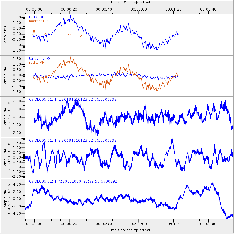
Signal To Noise
| Channel | StoN | STA | LTA |
| GS:DEC06:01:HHZ:20181010T23:32:56.650029Z | 1.394954 | 7.8256863E-7 | 5.609996E-7 |
| GS:DEC06:01:HHN:20181010T23:32:56.650029Z | 3.2050772 | 3.1065022E-6 | 9.692441E-7 |
| GS:DEC06:01:HHE:20181010T23:32:56.650029Z | 1.4052156 | 1.3714273E-6 | 9.759551E-7 |
| Arrivals |
| Ps | |
| PpPs | |
| PsPs/PpSs | |


