You are here: Home > Network List > OH - Ohio Seismic Network Stations List
> Station SSF2 Shawnee State Forest Ohio New > Earthquake Result Viewer
SSF2 Shawnee State Forest Ohio New - Earthquake Result Viewer
| Earthquake location: |
South Of Panama |
| Earthquake latitude/longitude: |
7.6/-82.3 |
| Earthquake time(UTC): |
2023/04/04 (094) 22:18:12 GMT |
| Earthquake Depth: |
10 km |
| Earthquake Magnitude: |
6.3 mww |
| Earthquake Catalog/Contributor: |
NEIC PDE/at |
|
| Network: |
OH Ohio Seismic Network |
| Station: |
SSF2 Shawnee State Forest Ohio New |
| Lat/Lon: |
38.69 N/83.13 W |
| Elevation: |
324 m |
|
| Distance: |
31.0 deg |
| Az: |
358.774 deg |
| Baz: |
178.447 deg |
| Ray Param: |
0.07924278 |
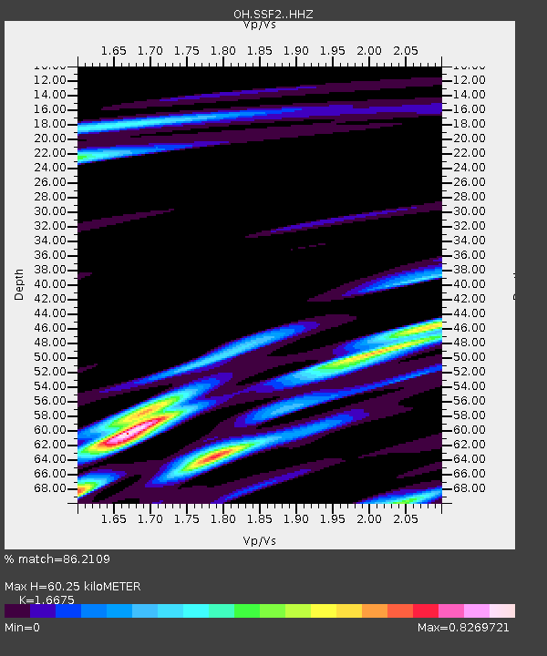
| Estimated Moho Depth: |
60.25 km |
| Estimated Crust Vp/Vs: |
1.67 |
| Assumed Crust Vp: |
6.232 km/s |
| Estimated Crust Vs: |
3.737 km/s |
| Estimated Crust Poisson's Ratio: |
0.22 |
|
| Radial Match: |
86.2109 % |
| Radial Bump: |
400 |
| Transverse Match: |
68.67612 % |
| Transverse Bump: |
400 |
| SOD ConfigId: |
30536071 |
| Insert Time: |
2023-04-18 22:46:14.277 +0000 |
| GWidth: |
2.5 |
| Max Bumps: |
400 |
| Tol: |
0.001 |
|

Signal To Noise
| Channel | StoN | STA | LTA |
| OH:SSF2: :HHZ:20230404T22:23:58.730011Z | 3.8211417 | 1.281307E-6 | 3.3532046E-7 |
| OH:SSF2: :HHN:20230404T22:23:58.730011Z | 2.5602725 | 7.6043756E-7 | 2.970143E-7 |
| OH:SSF2: :HHE:20230404T22:23:58.730011Z | 1.1056457 | 4.729797E-7 | 4.27786E-7 |
| Arrivals |
| Ps | 7.0 SECOND |
| PpPs | 24 SECOND |
| PsPs/PpSs | 31 SECOND |


