You are here: Home > Network List > TX - Texas Seismological Network Stations List
> Station WTFS Witchita Falls > Earthquake Result Viewer
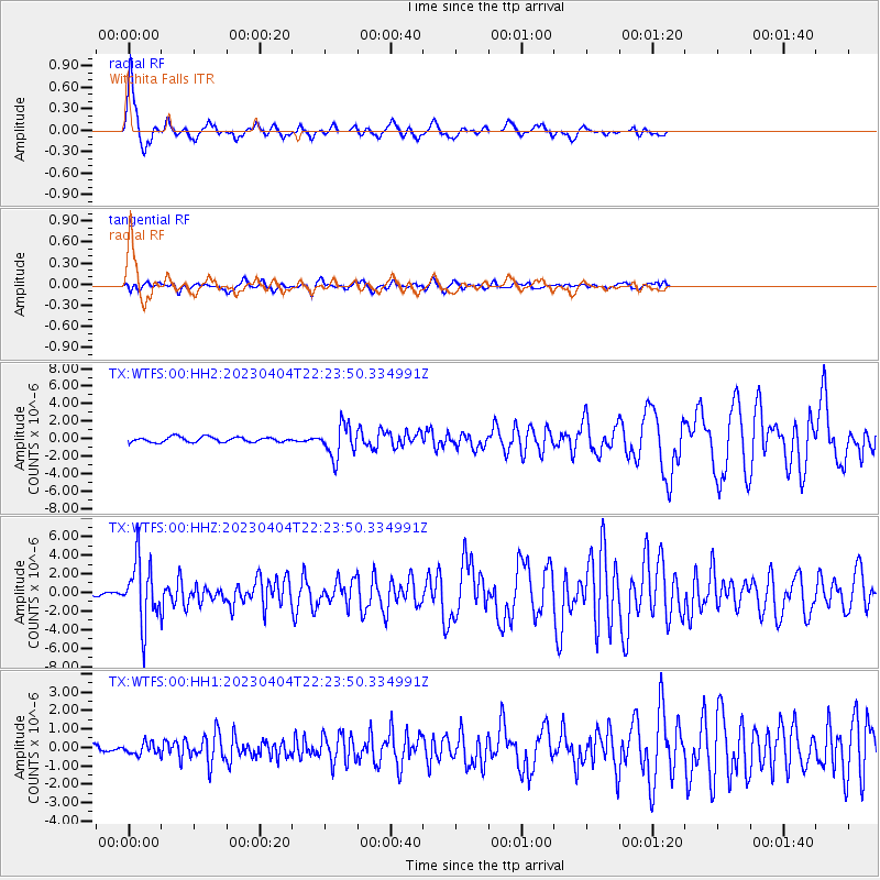
WTFS Witchita Falls - Earthquake Result Viewer

| Earthquake location: |
South Of Panama |
| Earthquake latitude/longitude: |
7.6/-82.3 |
| Earthquake time(UTC): |
2023/04/04 (094) 22:18:12 GMT |
| Earthquake Depth: |
10 km |
| Earthquake Magnitude: |
6.3 mww |
| Earthquake Catalog/Contributor: |
NEIC PDE/at |
|
| Network: |
TX Texas Seismological Network |
| Station: |
WTFS Witchita Falls |
| Lat/Lon: |
33.77 N/98.46 W |
| Elevation: |
277 m |
|
| Distance: |
30.0 deg |
| Az: |
332.433 deg |
| Baz: |
146.581 deg |
| Ray Param: |
0.079532534 |
| Estimated Moho Depth: |
59.75 km |
| Estimated Crust Vp/Vs: |
1.60 |
| Assumed Crust Vp: |
6.426 km/s |
| Estimated Crust Vs: |
4.016 km/s |
| Estimated Crust Poisson's Ratio: |
0.18 |
|
| Radial Match: |
85.48591 % |
| Radial Bump: |
270 |
| Transverse Match: |
60.744617 % |
| Transverse Bump: |
400 |
| SOD ConfigId: |
30536071 |
| Insert Time: |
2023-04-18 22:50:52.687 +0000 |
| GWidth: |
2.5 |
| Max Bumps: |
400 |
| Tol: |
0.001 |
|
Signal To Noise
| Channel | StoN | STA | LTA |
| TX:WTFS:00:HHZ:20230404T22:23:50.334991Z | 14.957259 | 3.3079134E-6 | 2.2115772E-7 |
| TX:WTFS:00:HH1:20230404T22:23:50.334991Z | 0.78661764 | 3.007727E-7 | 3.8236203E-7 |
| TX:WTFS:00:HH2:20230404T22:23:50.334991Z | 6.1541185 | 1.8209781E-6 | 2.9589586E-7 |
| Arrivals |
| Ps | 6.1 SECOND |
| PpPs | 22 SECOND |
| PsPs/PpSs | 28 SECOND |


