You are here: Home > Network List > TA - USArray Transportable Network (new EarthScope stations) Stations List
> Station 334A Lometa, TX, USA > Earthquake Result Viewer
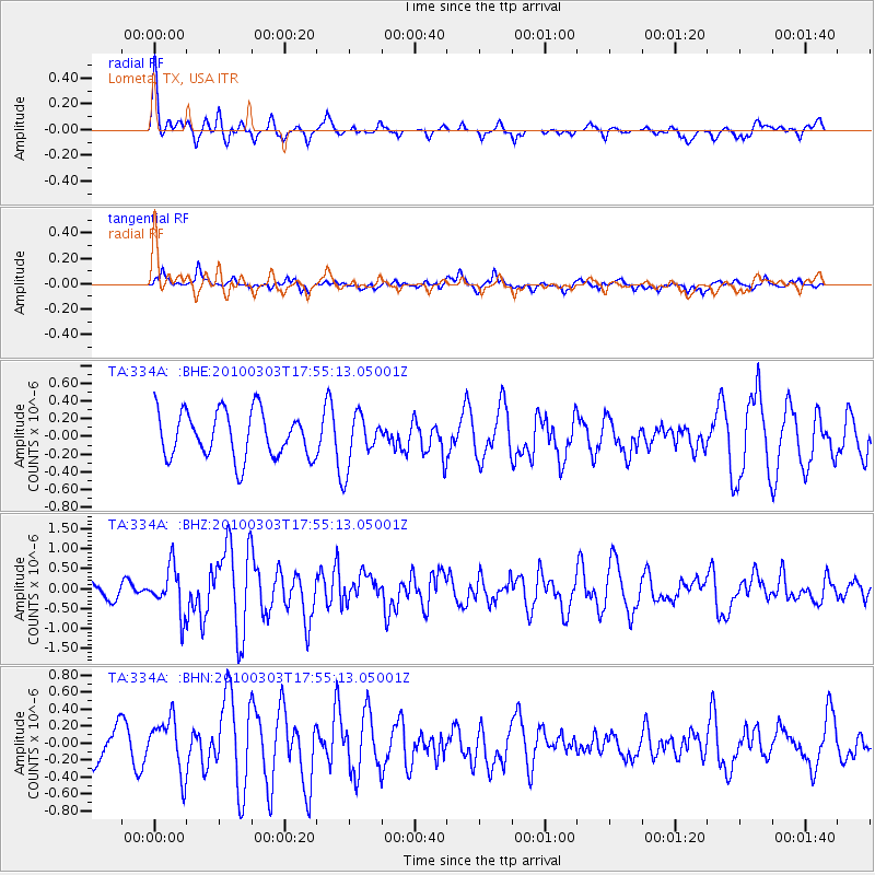
334A Lometa, TX, USA - Earthquake Result Viewer
*The percent match for this event was below the threshold and hence no stack was calculated.
| Earthquake location: |
Near Coast Of Central Chile |
| Earthquake latitude/longitude: |
-36.6/-73.4 |
| Earthquake time(UTC): |
2010/03/03 (062) 17:44:25 GMT |
| Earthquake Depth: |
20 km |
| Earthquake Magnitude: |
5.6 MB, 5.9 MS, 6.1 MW, 6.1 MW |
| Earthquake Catalog/Contributor: |
WHDF/NEIC |
|
| Network: |
TA USArray Transportable Network (new EarthScope stations) |
| Station: |
334A Lometa, TX, USA |
| Lat/Lon: |
31.33 N/98.24 W |
| Elevation: |
389 m |
|
| Distance: |
71.5 deg |
| Az: |
337.69 deg |
| Baz: |
159.087 deg |
| Ray Param: |
$rayparam |
*The percent match for this event was below the threshold and hence was not used in the summary stack. |
|
| Radial Match: |
69.807274 % |
| Radial Bump: |
400 |
| Transverse Match: |
48.540154 % |
| Transverse Bump: |
393 |
| SOD ConfigId: |
308276 |
| Insert Time: |
2010-06-22 15:25:36.933 +0000 |
| GWidth: |
2.5 |
| Max Bumps: |
400 |
| Tol: |
0.001 |
|
Signal To Noise
| Channel | StoN | STA | LTA |
| TA:334A: :BHZ:20100303T17:55:13.05001Z | 2.5649283 | 5.7473744E-7 | 2.2407544E-7 |
| TA:334A: :BHN:20100303T17:55:13.05001Z | 1.4524183 | 3.2595588E-7 | 2.2442288E-7 |
| TA:334A: :BHE:20100303T17:55:13.05001Z | 1.0945418 | 2.825374E-7 | 2.5813307E-7 |
| Arrivals |
| Ps | |
| PpPs | |
| PsPs/PpSs | |


