You are here: Home > Network List > UU - University of Utah Regional Network Stations List
> Station FORU South Mineral Mountains, UT, USA > Earthquake Result Viewer
FORU South Mineral Mountains, UT, USA - Earthquake Result Viewer
*The percent match for this event was below the threshold and hence no stack was calculated.
| Earthquake location: |
South Of Panama |
| Earthquake latitude/longitude: |
7.6/-82.3 |
| Earthquake time(UTC): |
2023/04/04 (094) 22:18:12 GMT |
| Earthquake Depth: |
10 km |
| Earthquake Magnitude: |
6.3 mww |
| Earthquake Catalog/Contributor: |
NEIC PDE/at |
|
| Network: |
UU University of Utah Regional Network |
| Station: |
FORU South Mineral Mountains, UT, USA |
| Lat/Lon: |
38.46 N/112.86 W |
| Elevation: |
1840 m |
|
| Distance: |
41.3 deg |
| Az: |
322.796 deg |
| Baz: |
130.222 deg |
| Ray Param: |
$rayparam |
*The percent match for this event was below the threshold and hence was not used in the summary stack. |
|
| Radial Match: |
61.47371 % |
| Radial Bump: |
400 |
| Transverse Match: |
52.526283 % |
| Transverse Bump: |
400 |
| SOD ConfigId: |
30536071 |
| Insert Time: |
2023-04-18 22:53:44.578 +0000 |
| GWidth: |
2.5 |
| Max Bumps: |
400 |
| Tol: |
0.001 |
|
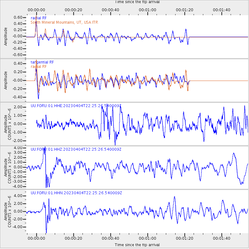
Signal To Noise
| Channel | StoN | STA | LTA |
| UU:FORU:01:HHZ:20230404T22:25:26.540009Z | 7.66002 | 1.7072196E-6 | 2.2287404E-7 |
| UU:FORU:01:HHN:20230404T22:25:26.540009Z | 6.668522 | 9.3104865E-7 | 1.3961844E-7 |
| UU:FORU:01:HHE:20230404T22:25:26.540009Z | 2.4147844 | 7.21192E-7 | 2.986569E-7 |
| Arrivals |
| Ps | |
| PpPs | |
| PsPs/PpSs | |


