You are here: Home > Network List > TA - USArray Transportable Network (new EarthScope stations) Stations List
> Station 234A Clairette, TX, USA > Earthquake Result Viewer
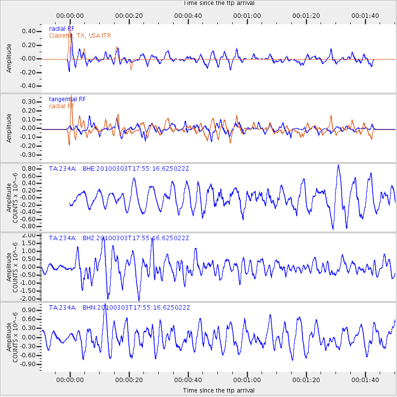
234A Clairette, TX, USA - Earthquake Result Viewer
*The percent match for this event was below the threshold and hence no stack was calculated.
| Earthquake location: |
Near Coast Of Central Chile |
| Earthquake latitude/longitude: |
-36.6/-73.4 |
| Earthquake time(UTC): |
2010/03/03 (062) 17:44:25 GMT |
| Earthquake Depth: |
20 km |
| Earthquake Magnitude: |
5.6 MB, 5.9 MS, 6.1 MW, 6.1 MW |
| Earthquake Catalog/Contributor: |
WHDF/NEIC |
|
| Network: |
TA USArray Transportable Network (new EarthScope stations) |
| Station: |
234A Clairette, TX, USA |
| Lat/Lon: |
32.00 N/98.14 W |
| Elevation: |
358 m |
|
| Distance: |
72.1 deg |
| Az: |
338.026 deg |
| Baz: |
159.245 deg |
| Ray Param: |
$rayparam |
*The percent match for this event was below the threshold and hence was not used in the summary stack. |
|
| Radial Match: |
61.91404 % |
| Radial Bump: |
400 |
| Transverse Match: |
57.204865 % |
| Transverse Bump: |
313 |
| SOD ConfigId: |
308276 |
| Insert Time: |
2010-06-22 15:25:49.150 +0000 |
| GWidth: |
2.5 |
| Max Bumps: |
400 |
| Tol: |
0.001 |
|
Signal To Noise
| Channel | StoN | STA | LTA |
| TA:234A: :BHZ:20100303T17:55:16.625022Z | 2.3609316 | 6.472624E-7 | 2.7415552E-7 |
| TA:234A: :BHN:20100303T17:55:16.625022Z | 0.9803218 | 2.5407536E-7 | 2.5917547E-7 |
| TA:234A: :BHE:20100303T17:55:16.625022Z | 1.0815046 | 2.2705898E-7 | 2.099473E-7 |
| Arrivals |
| Ps | |
| PpPs | |
| PsPs/PpSs | |


