You are here: Home > Network List > US - United States National Seismic Network Stations List
> Station DGMT Dagmar, Montana, USA > Earthquake Result Viewer
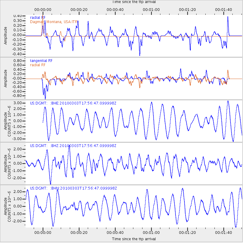
DGMT Dagmar, Montana, USA - Earthquake Result Viewer
*The percent match for this event was below the threshold and hence no stack was calculated.
| Earthquake location: |
Near Coast Of Central Chile |
| Earthquake latitude/longitude: |
-36.6/-73.4 |
| Earthquake time(UTC): |
2010/03/03 (062) 17:44:25 GMT |
| Earthquake Depth: |
20 km |
| Earthquake Magnitude: |
5.6 MB, 5.9 MS, 6.1 MW, 6.1 MW |
| Earthquake Catalog/Contributor: |
WHDF/NEIC |
|
| Network: |
US United States National Seismic Network |
| Station: |
DGMT Dagmar, Montana, USA |
| Lat/Lon: |
48.47 N/104.20 W |
| Elevation: |
0.0 m |
|
| Distance: |
89.0 deg |
| Az: |
340.052 deg |
| Baz: |
155.639 deg |
| Ray Param: |
$rayparam |
*The percent match for this event was below the threshold and hence was not used in the summary stack. |
|
| Radial Match: |
70.37631 % |
| Radial Bump: |
370 |
| Transverse Match: |
68.88574 % |
| Transverse Bump: |
349 |
| SOD ConfigId: |
308276 |
| Insert Time: |
2010-06-22 15:27:23.949 +0000 |
| GWidth: |
2.5 |
| Max Bumps: |
400 |
| Tol: |
0.001 |
|
Signal To Noise
| Channel | StoN | STA | LTA |
| US:DGMT: :BHZ:20100303T17:56:47.099998Z | 1.9787451 | 1.3703253E-6 | 6.9252246E-7 |
| US:DGMT: :BHN:20100303T17:56:47.099998Z | 0.81950366 | 9.715184E-7 | 1.185496E-6 |
| US:DGMT: :BHE:20100303T17:56:47.099998Z | 0.5725169 | 8.0214465E-7 | 1.4010847E-6 |
| Arrivals |
| Ps | |
| PpPs | |
| PsPs/PpSs | |


