You are here: Home > Network List > TA - USArray Transportable Network (new EarthScope stations) Stations List
> Station H17A Grant Village (NPS), Yellowstone Nt. Park, WY, USA > Earthquake Result Viewer
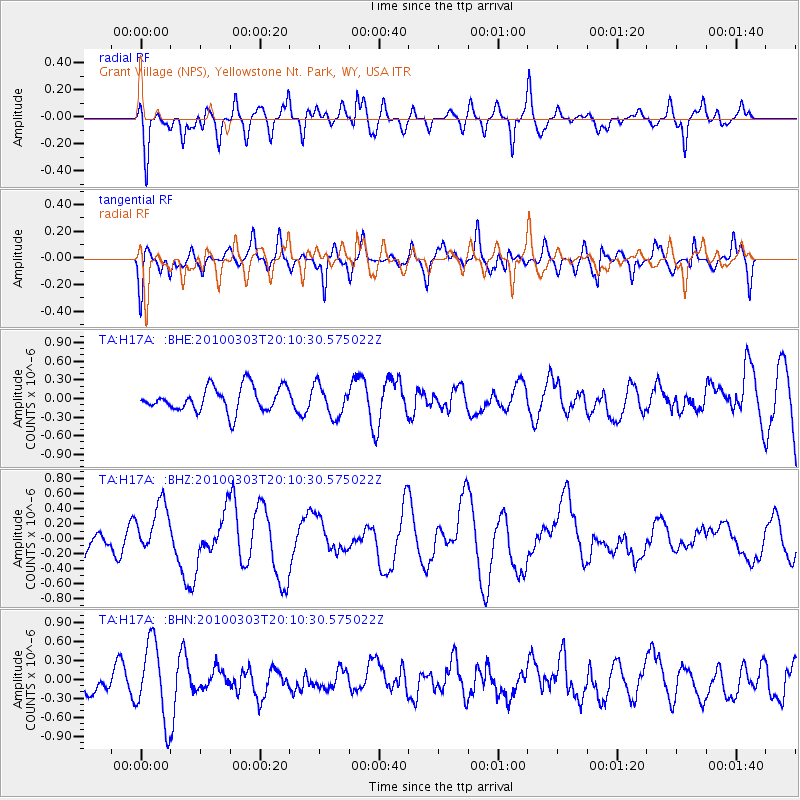
H17A Grant Village (NPS), Yellowstone Nt. Park, WY, USA - Earthquake Result Viewer
*The percent match for this event was below the threshold and hence no stack was calculated.
| Earthquake location: |
Near Coast Of Central Chile |
| Earthquake latitude/longitude: |
-33.4/-71.9 |
| Earthquake time(UTC): |
2010/03/03 (062) 19:58:29 GMT |
| Earthquake Depth: |
39 km |
| Earthquake Magnitude: |
5.5 MS, 5.3 MB, 5.8 MW, 5.6 MW |
| Earthquake Catalog/Contributor: |
WHDF/NEIC |
|
| Network: |
TA USArray Transportable Network (new EarthScope stations) |
| Station: |
H17A Grant Village (NPS), Yellowstone Nt. Park, WY, USA |
| Lat/Lon: |
44.40 N/110.58 W |
| Elevation: |
2400 m |
|
| Distance: |
85.1 deg |
| Az: |
333.259 deg |
| Baz: |
148.332 deg |
| Ray Param: |
$rayparam |
*The percent match for this event was below the threshold and hence was not used in the summary stack. |
|
| Radial Match: |
68.366554 % |
| Radial Bump: |
400 |
| Transverse Match: |
54.44785 % |
| Transverse Bump: |
400 |
| SOD ConfigId: |
308276 |
| Insert Time: |
2010-06-22 15:33:27.561 +0000 |
| GWidth: |
2.5 |
| Max Bumps: |
400 |
| Tol: |
0.001 |
|
Signal To Noise
| Channel | StoN | STA | LTA |
| TA:H17A: :BHZ:20100303T20:10:30.575022Z | 2.1313045 | 3.5097207E-7 | 1.6467476E-7 |
| TA:H17A: :BHN:20100303T20:10:30.575022Z | 3.5760193 | 6.0912134E-7 | 1.7033504E-7 |
| TA:H17A: :BHE:20100303T20:10:30.575022Z | 1.2659696 | 2.5050227E-7 | 1.9787383E-7 |
| Arrivals |
| Ps | |
| PpPs | |
| PsPs/PpSs | |


