You are here: Home > Network List > TA - USArray Transportable Network (new EarthScope stations) Stations List
> Station J21A Lysite, WY, USA > Earthquake Result Viewer
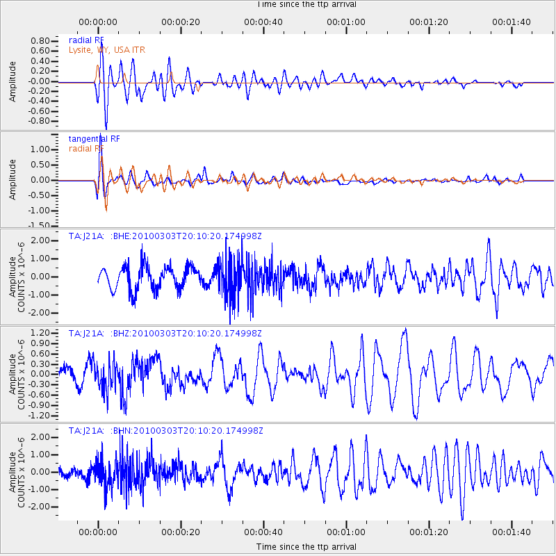
J21A Lysite, WY, USA - Earthquake Result Viewer
*The percent match for this event was below the threshold and hence no stack was calculated.
| Earthquake location: |
Near Coast Of Central Chile |
| Earthquake latitude/longitude: |
-33.4/-71.9 |
| Earthquake time(UTC): |
2010/03/03 (062) 19:58:29 GMT |
| Earthquake Depth: |
39 km |
| Earthquake Magnitude: |
5.5 MS, 5.3 MB, 5.8 MW, 5.6 MW |
| Earthquake Catalog/Contributor: |
WHDF/NEIC |
|
| Network: |
TA USArray Transportable Network (new EarthScope stations) |
| Station: |
J21A Lysite, WY, USA |
| Lat/Lon: |
43.35 N/107.45 W |
| Elevation: |
1913 m |
|
| Distance: |
83.0 deg |
| Az: |
334.684 deg |
| Baz: |
150.642 deg |
| Ray Param: |
$rayparam |
*The percent match for this event was below the threshold and hence was not used in the summary stack. |
|
| Radial Match: |
56.586567 % |
| Radial Bump: |
400 |
| Transverse Match: |
73.03445 % |
| Transverse Bump: |
400 |
| SOD ConfigId: |
308276 |
| Insert Time: |
2010-06-22 15:34:36.781 +0000 |
| GWidth: |
2.5 |
| Max Bumps: |
400 |
| Tol: |
0.001 |
|
Signal To Noise
| Channel | StoN | STA | LTA |
| TA:J21A: :BHZ:20100303T20:10:20.174998Z | 0.7796423 | 3.830113E-7 | 4.9126544E-7 |
| TA:J21A: :BHN:20100303T20:10:20.174998Z | 1.9301759 | 7.6651156E-7 | 3.9712006E-7 |
| TA:J21A: :BHE:20100303T20:10:20.174998Z | 1.679827 | 1.0499451E-6 | 6.250317E-7 |
| Arrivals |
| Ps | |
| PpPs | |
| PsPs/PpSs | |


