You are here: Home > Network List > SC - New Mexico Tech Seismic Network Stations List
> Station CL7 WIPP Site, New Mexico > Earthquake Result Viewer
CL7 WIPP Site, New Mexico - Earthquake Result Viewer
| Earthquake location: |
Kuril Islands |
| Earthquake latitude/longitude: |
49.9/155.3 |
| Earthquake time(UTC): |
2023/04/07 (097) 02:22:41 GMT |
| Earthquake Depth: |
86 km |
| Earthquake Magnitude: |
5.8 mww |
| Earthquake Catalog/Contributor: |
NEIC PDE/us |
|
| Network: |
SC New Mexico Tech Seismic Network |
| Station: |
CL7 WIPP Site, New Mexico |
| Lat/Lon: |
32.41 N/103.81 W |
| Elevation: |
1034 m |
|
| Distance: |
72.4 deg |
| Az: |
60.625 deg |
| Baz: |
318.183 deg |
| Ray Param: |
0.053517755 |
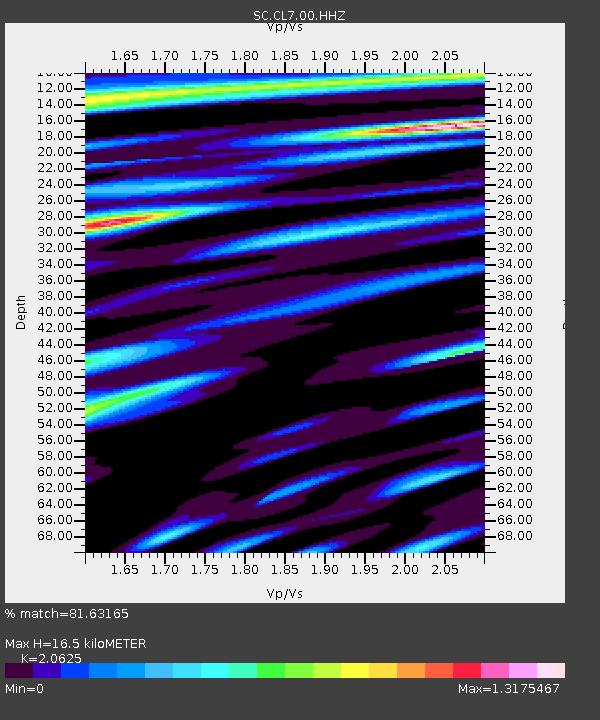
| Estimated Moho Depth: |
16.5 km |
| Estimated Crust Vp/Vs: |
2.06 |
| Assumed Crust Vp: |
6.129 km/s |
| Estimated Crust Vs: |
2.972 km/s |
| Estimated Crust Poisson's Ratio: |
0.35 |
|
| Radial Match: |
81.63165 % |
| Radial Bump: |
400 |
| Transverse Match: |
71.16556 % |
| Transverse Bump: |
400 |
| SOD ConfigId: |
30536071 |
| Insert Time: |
2023-04-21 02:47:58.037 +0000 |
| GWidth: |
2.5 |
| Max Bumps: |
400 |
| Tol: |
0.001 |
|

Signal To Noise
| Channel | StoN | STA | LTA |
| SC:CL7:00:HHZ:20230407T02:33:26.749004Z | 6.749244 | 7.810823E-8 | 1.1572886E-8 |
| SC:CL7:00:HHN:20230407T02:33:26.749004Z | 1.2397985 | 2.2801744E-8 | 1.8391491E-8 |
| SC:CL7:00:HHE:20230407T02:33:26.749004Z | 1.2512809 | 2.4678748E-8 | 1.9722789E-8 |
| Arrivals |
| Ps | 2.9 SECOND |
| PpPs | 8.0 SECOND |
| PsPs/PpSs | 11 SECOND |


