You are here: Home > Network List > US - United States National Seismic Network Stations List
> Station CBKS Cedar Bluff, Kansas, USA > Earthquake Result Viewer
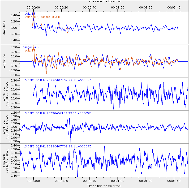
CBKS Cedar Bluff, Kansas, USA - Earthquake Result Viewer
*The percent match for this event was below the threshold and hence no stack was calculated.
| Earthquake location: |
Kuril Islands |
| Earthquake latitude/longitude: |
49.9/155.3 |
| Earthquake time(UTC): |
2023/04/07 (097) 02:22:41 GMT |
| Earthquake Depth: |
86 km |
| Earthquake Magnitude: |
5.8 mww |
| Earthquake Catalog/Contributor: |
NEIC PDE/us |
|
| Network: |
US United States National Seismic Network |
| Station: |
CBKS Cedar Bluff, Kansas, USA |
| Lat/Lon: |
38.81 N/99.74 W |
| Elevation: |
677 m |
|
| Distance: |
69.8 deg |
| Az: |
53.512 deg |
| Baz: |
318.239 deg |
| Ray Param: |
$rayparam |
*The percent match for this event was below the threshold and hence was not used in the summary stack. |
|
| Radial Match: |
53.127293 % |
| Radial Bump: |
400 |
| Transverse Match: |
50.69877 % |
| Transverse Bump: |
400 |
| SOD ConfigId: |
30536071 |
| Insert Time: |
2023-04-21 02:50:45.073 +0000 |
| GWidth: |
2.5 |
| Max Bumps: |
400 |
| Tol: |
0.001 |
|
Signal To Noise
| Channel | StoN | STA | LTA |
| US:CBKS:00:BHZ:20230407T02:33:11.400005Z | 1.7988422 | 1.859736E-7 | 1.03385176E-7 |
| US:CBKS:00:BH1:20230407T02:33:11.400005Z | 1.871032 | 1.7164551E-7 | 9.1738414E-8 |
| US:CBKS:00:BH2:20230407T02:33:11.400005Z | 0.85413474 | 9.3814684E-8 | 1.0983593E-7 |
| Arrivals |
| Ps | |
| PpPs | |
| PsPs/PpSs | |


