You are here: Home > Network List > UW - Pacific Northwest Regional Seismic Network Stations List
> Station HOOD Mt Hood Meadows, OR CREST BB SMO > Earthquake Result Viewer
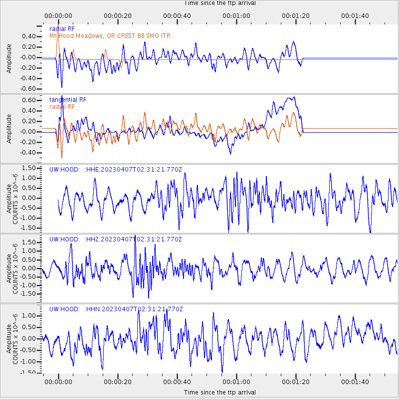
HOOD Mt Hood Meadows, OR CREST BB SMO - Earthquake Result Viewer
*The percent match for this event was below the threshold and hence no stack was calculated.
| Earthquake location: |
Kuril Islands |
| Earthquake latitude/longitude: |
49.9/155.3 |
| Earthquake time(UTC): |
2023/04/07 (097) 02:22:41 GMT |
| Earthquake Depth: |
86 km |
| Earthquake Magnitude: |
5.8 mww |
| Earthquake Catalog/Contributor: |
NEIC PDE/us |
|
| Network: |
UW Pacific Northwest Regional Seismic Network |
| Station: |
HOOD Mt Hood Meadows, OR CREST BB SMO |
| Lat/Lon: |
45.32 N/121.65 W |
| Elevation: |
1520 m |
|
| Distance: |
53.5 deg |
| Az: |
60.647 deg |
| Baz: |
306.913 deg |
| Ray Param: |
$rayparam |
*The percent match for this event was below the threshold and hence was not used in the summary stack. |
|
| Radial Match: |
52.719604 % |
| Radial Bump: |
400 |
| Transverse Match: |
53.329464 % |
| Transverse Bump: |
400 |
| SOD ConfigId: |
30536071 |
| Insert Time: |
2023-04-21 02:52:28.771 +0000 |
| GWidth: |
2.5 |
| Max Bumps: |
400 |
| Tol: |
0.001 |
|
Signal To Noise
| Channel | StoN | STA | LTA |
| UW:HOOD: :HHZ:20230407T02:31:21.770Z | 2.0535212 | 6.0494216E-7 | 2.9458775E-7 |
| UW:HOOD: :HHN:20230407T02:31:21.770Z | 1.9522282 | 7.044378E-7 | 3.6083784E-7 |
| UW:HOOD: :HHE:20230407T02:31:21.770Z | 1.0055088 | 4.4782337E-7 | 4.453699E-7 |
| Arrivals |
| Ps | |
| PpPs | |
| PsPs/PpSs | |


