You are here: Home > Network List > IU - Global Seismograph Network (GSN - IRIS/USGS) Stations List
> Station FURI Mt. Furi, Ethiopia > Earthquake Result Viewer
FURI Mt. Furi, Ethiopia - Earthquake Result Viewer
| Earthquake location: |
Taiwan |
| Earthquake latitude/longitude: |
22.9/120.8 |
| Earthquake time(UTC): |
2010/03/04 (063) 00:18:51 GMT |
| Earthquake Depth: |
21 km |
| Earthquake Magnitude: |
6.2 MB, 6.2 MS, 6.3 MW, 6.2 MW |
| Earthquake Catalog/Contributor: |
WHDF/NEIC |
|
| Network: |
IU Global Seismograph Network (GSN - IRIS/USGS) |
| Station: |
FURI Mt. Furi, Ethiopia |
| Lat/Lon: |
8.90 N/38.68 E |
| Elevation: |
2570 m |
|
| Distance: |
79.4 deg |
| Az: |
275.204 deg |
| Baz: |
68.314 deg |
| Ray Param: |
0.048986755 |
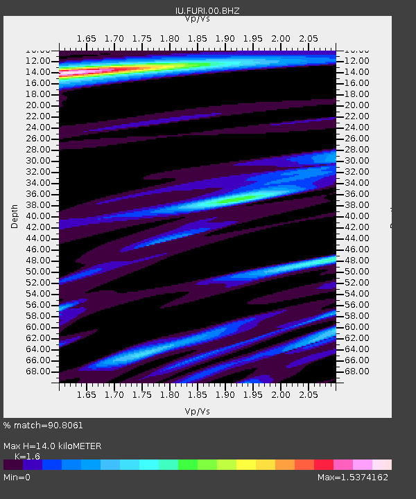
| Estimated Moho Depth: |
14.0 km |
| Estimated Crust Vp/Vs: |
1.60 |
| Assumed Crust Vp: |
6.464 km/s |
| Estimated Crust Vs: |
4.04 km/s |
| Estimated Crust Poisson's Ratio: |
0.18 |
|
| Radial Match: |
90.8061 % |
| Radial Bump: |
400 |
| Transverse Match: |
82.66225 % |
| Transverse Bump: |
400 |
| SOD ConfigId: |
308276 |
| Insert Time: |
2010-06-22 15:45:48.530 +0000 |
| GWidth: |
2.5 |
| Max Bumps: |
400 |
| Tol: |
0.001 |
|

Signal To Noise
| Channel | StoN | STA | LTA |
| IU:FURI:00:BHZ:20100304T00:30:24.279014Z | 0.61770403 | 5.055709E-8 | 8.1846785E-8 |
| IU:FURI:00:BHN:20100304T00:30:24.279014Z | 0.8997161 | 5.8887323E-8 | 6.5451005E-8 |
| IU:FURI:00:BHE:20100304T00:30:24.279014Z | 1.4881637 | 9.1038515E-8 | 6.1175065E-8 |
| Arrivals |
| Ps | 1.3 SECOND |
| PpPs | 5.5 SECOND |
| PsPs/PpSs | 6.8 SECOND |


