You are here: Home > Network List > TM - Thai Seismic Monitoring Network Stations List
> Station LOEI Nam Man, Loei > Earthquake Result Viewer
LOEI Nam Man, Loei - Earthquake Result Viewer
| Earthquake location: |
Bismarck Sea |
| Earthquake latitude/longitude: |
-3.6/149.0 |
| Earthquake time(UTC): |
2023/04/10 (100) 01:05:49 GMT |
| Earthquake Depth: |
10 km |
| Earthquake Magnitude: |
5.9 mww |
| Earthquake Catalog/Contributor: |
NEIC PDE/us |
|
| Network: |
TM Thai Seismic Monitoring Network |
| Station: |
LOEI Nam Man, Loei |
| Lat/Lon: |
17.51 N/101.62 E |
| Elevation: |
305 m |
|
| Distance: |
51.2 deg |
| Az: |
295.745 deg |
| Baz: |
109.592 deg |
| Ray Param: |
0.06756798 |
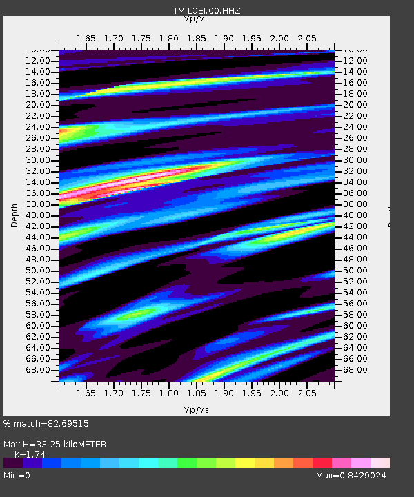
| Estimated Moho Depth: |
33.25 km |
| Estimated Crust Vp/Vs: |
1.74 |
| Assumed Crust Vp: |
6.35 km/s |
| Estimated Crust Vs: |
3.649 km/s |
| Estimated Crust Poisson's Ratio: |
0.25 |
|
| Radial Match: |
82.69515 % |
| Radial Bump: |
395 |
| Transverse Match: |
56.598793 % |
| Transverse Bump: |
400 |
| SOD ConfigId: |
30536071 |
| Insert Time: |
2023-04-24 01:18:15.882 +0000 |
| GWidth: |
2.5 |
| Max Bumps: |
400 |
| Tol: |
0.001 |
|

Signal To Noise
| Channel | StoN | STA | LTA |
| TM:LOEI:00:HHZ:20230410T01:14:21.739971Z | 3.8366747 | 2.4335756E-7 | 6.342929E-8 |
| TM:LOEI:00:HHN:20230410T01:14:21.739971Z | 1.3005126 | 8.751862E-8 | 6.729548E-8 |
| TM:LOEI:00:HHE:20230410T01:14:21.739971Z | 2.8419895 | 1.08693804E-7 | 3.8245673E-8 |
| Arrivals |
| Ps | 4.1 SECOND |
| PpPs | 14 SECOND |
| PsPs/PpSs | 18 SECOND |


