You are here: Home > Network List > AG - Arkansas Seismic Network Stations List
> Station WLAR White Oak Lake,AR > Earthquake Result Viewer
WLAR White Oak Lake,AR - Earthquake Result Viewer
| Earthquake location: |
Northwest Of Kuril Islands |
| Earthquake latitude/longitude: |
52.7/153.7 |
| Earthquake time(UTC): |
2018/10/13 (286) 11:10:19 GMT |
| Earthquake Depth: |
397 km |
| Earthquake Magnitude: |
6.7 Mi |
| Earthquake Catalog/Contributor: |
NEIC PDE/pt |
|
| Network: |
AG Arkansas Seismic Network |
| Station: |
WLAR White Oak Lake,AR |
| Lat/Lon: |
33.69 N/93.11 W |
| Elevation: |
77 m |
|
| Distance: |
76.2 deg |
| Az: |
52.089 deg |
| Baz: |
324.839 deg |
| Ray Param: |
0.0499877 |
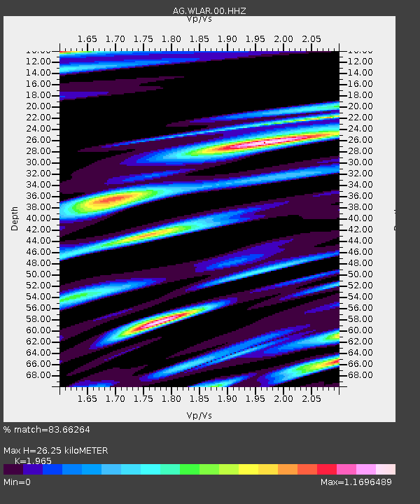
| Estimated Moho Depth: |
26.25 km |
| Estimated Crust Vp/Vs: |
1.97 |
| Assumed Crust Vp: |
6.245 km/s |
| Estimated Crust Vs: |
3.178 km/s |
| Estimated Crust Poisson's Ratio: |
0.33 |
|
| Radial Match: |
83.66264 % |
| Radial Bump: |
329 |
| Transverse Match: |
66.77486 % |
| Transverse Bump: |
340 |
| SOD ConfigId: |
3045211 |
| Insert Time: |
2018-10-27 11:18:06.498 +0000 |
| GWidth: |
2.5 |
| Max Bumps: |
400 |
| Tol: |
0.001 |
|
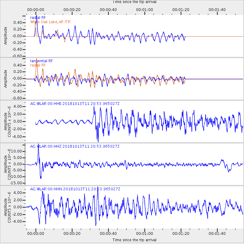
Signal To Noise
| Channel | StoN | STA | LTA |
| AG:WLAR:00:HHZ:20181013T11:20:53.965027Z | 34.381733 | 5.798793E-6 | 1.6865913E-7 |
| AG:WLAR:00:HHN:20181013T11:20:53.965027Z | 8.117893 | 2.22285E-6 | 2.7382106E-7 |
| AG:WLAR:00:HHE:20181013T11:20:53.965027Z | 6.1019645 | 2.0793825E-6 | 3.4077263E-7 |
| Arrivals |
| Ps | 4.2 SECOND |
| PpPs | 12 SECOND |
| PsPs/PpSs | 16 SECOND |


