You are here: Home > Network List > TA - USArray Transportable Network (new EarthScope stations) Stations List
> Station S31A Mullinville, KS, USA > Earthquake Result Viewer
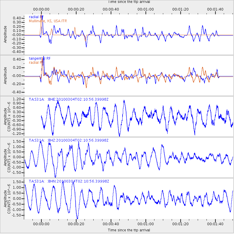
S31A Mullinville, KS, USA - Earthquake Result Viewer
*The percent match for this event was below the threshold and hence no stack was calculated.
| Earthquake location: |
Off Coast Of Central Chile |
| Earthquake latitude/longitude: |
-33.2/-72.1 |
| Earthquake time(UTC): |
2010/03/04 (063) 01:59:48 GMT |
| Earthquake Depth: |
24 km |
| Earthquake Magnitude: |
5.6 MB, 5.9 MS, 6.0 MW, 6.0 MW |
| Earthquake Catalog/Contributor: |
WHDF/NEIC |
|
| Network: |
TA USArray Transportable Network (new EarthScope stations) |
| Station: |
S31A Mullinville, KS, USA |
| Lat/Lon: |
37.62 N/99.48 W |
| Elevation: |
700 m |
|
| Distance: |
74.9 deg |
| Az: |
337.796 deg |
| Baz: |
156.487 deg |
| Ray Param: |
$rayparam |
*The percent match for this event was below the threshold and hence was not used in the summary stack. |
|
| Radial Match: |
53.437126 % |
| Radial Bump: |
400 |
| Transverse Match: |
67.32473 % |
| Transverse Bump: |
400 |
| SOD ConfigId: |
308276 |
| Insert Time: |
2010-06-22 15:55:31.074 +0000 |
| GWidth: |
2.5 |
| Max Bumps: |
400 |
| Tol: |
0.001 |
|
Signal To Noise
| Channel | StoN | STA | LTA |
| TA:S31A: :BHZ:20100304T02:10:56.39998Z | 2.0618477 | 1.0654209E-6 | 5.167311E-7 |
| TA:S31A: :BHN:20100304T02:10:56.39998Z | 1.262706 | 6.4497203E-7 | 5.107856E-7 |
| TA:S31A: :BHE:20100304T02:10:56.39998Z | 1.2698458 | 6.654983E-7 | 5.240781E-7 |
| Arrivals |
| Ps | |
| PpPs | |
| PsPs/PpSs | |


