You are here: Home > Network List > AG - Arkansas Seismic Network Stations List
> Station X40A Basin Creek Farm, Marlvern, AR > Earthquake Result Viewer
X40A Basin Creek Farm, Marlvern, AR - Earthquake Result Viewer

| Earthquake location: |
Vancouver Island, Canada Region |
| Earthquake latitude/longitude: |
49.2/-129.6 |
| Earthquake time(UTC): |
2023/04/13 (103) 15:54:54 GMT |
| Earthquake Depth: |
8.2 km |
| Earthquake Magnitude: |
6.0 mww |
| Earthquake Catalog/Contributor: |
NEIC PDE/us |
|
| Network: |
AG Arkansas Seismic Network |
| Station: |
X40A Basin Creek Farm, Marlvern, AR |
| Lat/Lon: |
34.49 N/92.83 W |
| Elevation: |
158 m |
|
| Distance: |
30.7 deg |
| Az: |
104.794 deg |
| Baz: |
309.886 deg |
| Ray Param: |
0.07933448 |
| Estimated Moho Depth: |
16.75 km |
| Estimated Crust Vp/Vs: |
1.60 |
| Assumed Crust Vp: |
6.498 km/s |
| Estimated Crust Vs: |
4.061 km/s |
| Estimated Crust Poisson's Ratio: |
0.18 |
|
| Radial Match: |
82.58436 % |
| Radial Bump: |
321 |
| Transverse Match: |
63.48354 % |
| Transverse Bump: |
400 |
| SOD ConfigId: |
30536071 |
| Insert Time: |
2023-04-27 15:56:05.223 +0000 |
| GWidth: |
2.5 |
| Max Bumps: |
400 |
| Tol: |
0.001 |
|
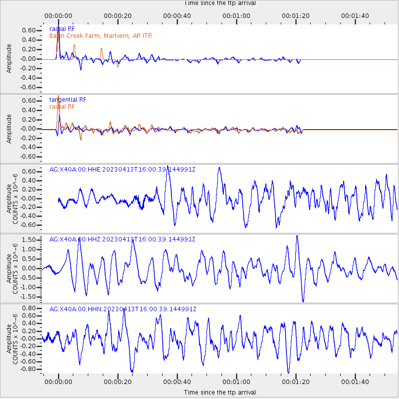
Signal To Noise
| Channel | StoN | STA | LTA |
| AG:X40A:00:HHZ:20230413T16:00:39.144991Z | 5.0139995 | 4.5634994E-7 | 9.101516E-8 |
| AG:X40A:00:HHN:20230413T16:00:39.144991Z | 1.8054029 | 1.5431456E-7 | 8.547375E-8 |
| AG:X40A:00:HHE:20230413T16:00:39.144991Z | 1.020156 | 9.951311E-8 | 9.754695E-8 |
| Arrivals |
| Ps | 1.7 SECOND |
| PpPs | 6.1 SECOND |
| PsPs/PpSs | 7.8 SECOND |


