You are here: Home > Network List > LD - Lamont-Doherty Cooperative Seismographic Network Stations List
> Station GEDE Greenville, DE, USA > Earthquake Result Viewer
GEDE Greenville, DE, USA - Earthquake Result Viewer
| Earthquake location: |
Vancouver Island, Canada Region |
| Earthquake latitude/longitude: |
49.2/-129.6 |
| Earthquake time(UTC): |
2023/04/13 (103) 15:54:54 GMT |
| Earthquake Depth: |
8.2 km |
| Earthquake Magnitude: |
6.0 mww |
| Earthquake Catalog/Contributor: |
NEIC PDE/us |
|
| Network: |
LD Lamont-Doherty Cooperative Seismographic Network |
| Station: |
GEDE Greenville, DE, USA |
| Lat/Lon: |
39.81 N/75.64 W |
| Elevation: |
105 m |
|
| Distance: |
38.8 deg |
| Az: |
83.081 deg |
| Baz: |
302.341 deg |
| Ray Param: |
0.07536256 |
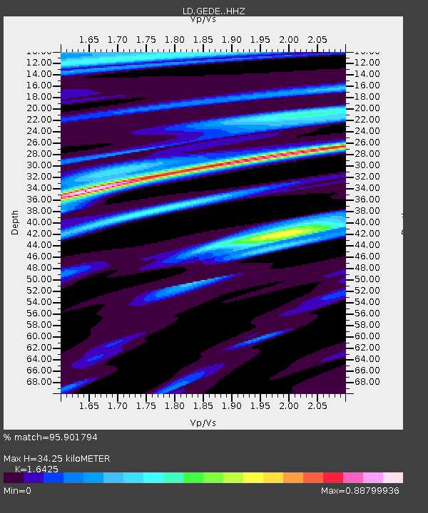
| Estimated Moho Depth: |
34.25 km |
| Estimated Crust Vp/Vs: |
1.64 |
| Assumed Crust Vp: |
6.287 km/s |
| Estimated Crust Vs: |
3.828 km/s |
| Estimated Crust Poisson's Ratio: |
0.21 |
|
| Radial Match: |
95.901794 % |
| Radial Bump: |
192 |
| Transverse Match: |
71.627686 % |
| Transverse Bump: |
375 |
| SOD ConfigId: |
30536071 |
| Insert Time: |
2023-04-27 16:02:38.599 +0000 |
| GWidth: |
2.5 |
| Max Bumps: |
400 |
| Tol: |
0.001 |
|

Signal To Noise
| Channel | StoN | STA | LTA |
| LD:GEDE: :HHZ:20230413T16:01:49.010012Z | 4.7504826 | 7.398133E-7 | 1.5573436E-7 |
| LD:GEDE: :HHN:20230413T16:01:49.010012Z | 0.93753844 | 1.4555108E-7 | 1.5524812E-7 |
| LD:GEDE: :HHE:20230413T16:01:49.010012Z | 1.6444294 | 2.5991372E-7 | 1.5805708E-7 |
| Arrivals |
| Ps | 3.8 SECOND |
| PpPs | 13 SECOND |
| PsPs/PpSs | 17 SECOND |


