You are here: Home > Network List > N4 - Central and EAstern US Network Stations List
> Station Q56A Snyder Ridge, Maysville, WV, USA > Earthquake Result Viewer
Q56A Snyder Ridge, Maysville, WV, USA - Earthquake Result Viewer
| Earthquake location: |
Vancouver Island, Canada Region |
| Earthquake latitude/longitude: |
49.2/-129.6 |
| Earthquake time(UTC): |
2023/04/13 (103) 15:54:54 GMT |
| Earthquake Depth: |
8.2 km |
| Earthquake Magnitude: |
6.0 mww |
| Earthquake Catalog/Contributor: |
NEIC PDE/us |
|
| Network: |
N4 Central and EAstern US Network |
| Station: |
Q56A Snyder Ridge, Maysville, WV, USA |
| Lat/Lon: |
39.04 N/79.19 W |
| Elevation: |
430 m |
|
| Distance: |
36.9 deg |
| Az: |
86.55 deg |
| Baz: |
302.833 deg |
| Ray Param: |
0.076440014 |
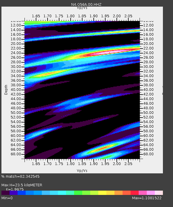
| Estimated Moho Depth: |
23.5 km |
| Estimated Crust Vp/Vs: |
1.97 |
| Assumed Crust Vp: |
6.159 km/s |
| Estimated Crust Vs: |
3.13 km/s |
| Estimated Crust Poisson's Ratio: |
0.33 |
|
| Radial Match: |
82.342545 % |
| Radial Bump: |
400 |
| Transverse Match: |
43.940453 % |
| Transverse Bump: |
400 |
| SOD ConfigId: |
30536071 |
| Insert Time: |
2023-04-27 16:04:32.574 +0000 |
| GWidth: |
2.5 |
| Max Bumps: |
400 |
| Tol: |
0.001 |
|

Signal To Noise
| Channel | StoN | STA | LTA |
| N4:Q56A:00:HHZ:20230413T16:01:32.959993Z | 2.5051029 | 8.469785E-7 | 3.3810127E-7 |
| N4:Q56A:00:HH1:20230413T16:01:32.959993Z | 1.570482 | 3.357033E-7 | 2.1375813E-7 |
| N4:Q56A:00:HH2:20230413T16:01:32.959993Z | 2.0568156 | 3.4746395E-7 | 1.6893294E-7 |
| Arrivals |
| Ps | 3.9 SECOND |
| PpPs | 11 SECOND |
| PsPs/PpSs | 15 SECOND |


