You are here: Home > Network List > N4 - Central and EAstern US Network Stations List
> Station S44A Carbondale, IL, USA > Earthquake Result Viewer
S44A Carbondale, IL, USA - Earthquake Result Viewer
| Earthquake location: |
Vancouver Island, Canada Region |
| Earthquake latitude/longitude: |
49.2/-129.6 |
| Earthquake time(UTC): |
2023/04/13 (103) 15:54:54 GMT |
| Earthquake Depth: |
8.2 km |
| Earthquake Magnitude: |
6.0 mww |
| Earthquake Catalog/Contributor: |
NEIC PDE/us |
|
| Network: |
N4 Central and EAstern US Network |
| Station: |
S44A Carbondale, IL, USA |
| Lat/Lon: |
37.69 N/89.26 W |
| Elevation: |
155 m |
|
| Distance: |
31.1 deg |
| Az: |
96.414 deg |
| Baz: |
304.793 deg |
| Ray Param: |
0.0792082 |
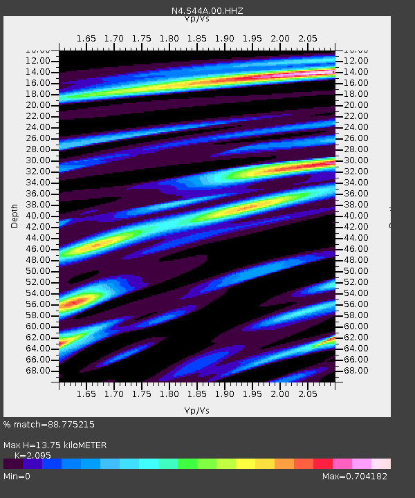
| Estimated Moho Depth: |
13.75 km |
| Estimated Crust Vp/Vs: |
2.10 |
| Assumed Crust Vp: |
6.444 km/s |
| Estimated Crust Vs: |
3.076 km/s |
| Estimated Crust Poisson's Ratio: |
0.35 |
|
| Radial Match: |
88.775215 % |
| Radial Bump: |
357 |
| Transverse Match: |
70.388405 % |
| Transverse Bump: |
400 |
| SOD ConfigId: |
30536071 |
| Insert Time: |
2023-04-27 16:04:40.205 +0000 |
| GWidth: |
2.5 |
| Max Bumps: |
400 |
| Tol: |
0.001 |
|

Signal To Noise
| Channel | StoN | STA | LTA |
| N4:S44A:00:HHZ:20230413T16:00:42.369997Z | 5.8740435 | 9.103306E-7 | 1.5497513E-7 |
| N4:S44A:00:HH1:20230413T16:00:42.369997Z | 2.5537953 | 3.3599642E-7 | 1.3156748E-7 |
| N4:S44A:00:HH2:20230413T16:00:42.369997Z | 4.7352743 | 5.047201E-7 | 1.065873E-7 |
| Arrivals |
| Ps | 2.5 SECOND |
| PpPs | 6.2 SECOND |
| PsPs/PpSs | 8.7 SECOND |


