You are here: Home > Network List > N4 - Central and EAstern US Network Stations List
> Station V58A WIndy Hill, Pittsboro, NC, USA > Earthquake Result Viewer
V58A WIndy Hill, Pittsboro, NC, USA - Earthquake Result Viewer
| Earthquake location: |
Vancouver Island, Canada Region |
| Earthquake latitude/longitude: |
49.2/-129.6 |
| Earthquake time(UTC): |
2023/04/13 (103) 15:54:54 GMT |
| Earthquake Depth: |
8.2 km |
| Earthquake Magnitude: |
6.0 mww |
| Earthquake Catalog/Contributor: |
NEIC PDE/us |
|
| Network: |
N4 Central and EAstern US Network |
| Station: |
V58A WIndy Hill, Pittsboro, NC, USA |
| Lat/Lon: |
35.79 N/79.11 W |
| Elevation: |
127 m |
|
| Distance: |
38.8 deg |
| Az: |
90.844 deg |
| Baz: |
306.267 deg |
| Ray Param: |
0.07537284 |
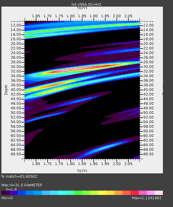
| Estimated Moho Depth: |
31.0 km |
| Estimated Crust Vp/Vs: |
1.80 |
| Assumed Crust Vp: |
6.565 km/s |
| Estimated Crust Vs: |
3.647 km/s |
| Estimated Crust Poisson's Ratio: |
0.28 |
|
| Radial Match: |
83.60582 % |
| Radial Bump: |
400 |
| Transverse Match: |
49.2137 % |
| Transverse Bump: |
400 |
| SOD ConfigId: |
30536071 |
| Insert Time: |
2023-04-27 16:05:01.019 +0000 |
| GWidth: |
2.5 |
| Max Bumps: |
400 |
| Tol: |
0.001 |
|

Signal To Noise
| Channel | StoN | STA | LTA |
| N4:V58A:00:HHZ:20230413T16:01:48.859987Z | 2.4193928 | 6.229533E-7 | 2.574833E-7 |
| N4:V58A:00:HH1:20230413T16:01:48.859987Z | 2.3807902 | 4.4711715E-7 | 1.8780199E-7 |
| N4:V58A:00:HH2:20230413T16:01:48.859987Z | 2.2941778 | 3.571406E-7 | 1.556726E-7 |
| Arrivals |
| Ps | 4.1 SECOND |
| PpPs | 12 SECOND |
| PsPs/PpSs | 16 SECOND |


