You are here: Home > Network List > NE - New England Seismic Network Stations List
> Station EMMW Machias, ME, USA > Earthquake Result Viewer
EMMW Machias, ME, USA - Earthquake Result Viewer
| Earthquake location: |
Vancouver Island, Canada Region |
| Earthquake latitude/longitude: |
49.2/-129.6 |
| Earthquake time(UTC): |
2023/04/13 (103) 15:54:54 GMT |
| Earthquake Depth: |
8.2 km |
| Earthquake Magnitude: |
6.0 mww |
| Earthquake Catalog/Contributor: |
NEIC PDE/us |
|
| Network: |
NE New England Seismic Network |
| Station: |
EMMW Machias, ME, USA |
| Lat/Lon: |
44.71 N/67.46 W |
| Elevation: |
35 m |
|
| Distance: |
41.6 deg |
| Az: |
71.762 deg |
| Baz: |
299.172 deg |
| Ray Param: |
0.073714904 |
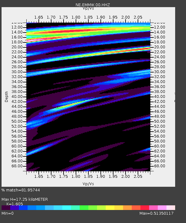
| Estimated Moho Depth: |
17.25 km |
| Estimated Crust Vp/Vs: |
1.61 |
| Assumed Crust Vp: |
6.419 km/s |
| Estimated Crust Vs: |
4.0 km/s |
| Estimated Crust Poisson's Ratio: |
0.18 |
|
| Radial Match: |
81.95744 % |
| Radial Bump: |
400 |
| Transverse Match: |
43.665173 % |
| Transverse Bump: |
400 |
| SOD ConfigId: |
30536071 |
| Insert Time: |
2023-04-27 16:05:18.466 +0000 |
| GWidth: |
2.5 |
| Max Bumps: |
400 |
| Tol: |
0.001 |
|

Signal To Noise
| Channel | StoN | STA | LTA |
| NE:EMMW:00:HHZ:20230413T16:02:11.61899Z | 2.9287274 | 5.293125E-7 | 1.8073123E-7 |
| NE:EMMW:00:HH1:20230413T16:02:11.61899Z | 1.6357951 | 2.80152E-7 | 1.712635E-7 |
| NE:EMMW:00:HH2:20230413T16:02:11.61899Z | 1.2311918 | 3.305836E-7 | 2.68507E-7 |
| Arrivals |
| Ps | 1.8 SECOND |
| PpPs | 6.5 SECOND |
| PsPs/PpSs | 8.2 SECOND |


