You are here: Home > Network List > CO - South Carolina Seismic Network Stations List
> Station SUMMV Summerville Airport, SC, USA > Earthquake Result Viewer
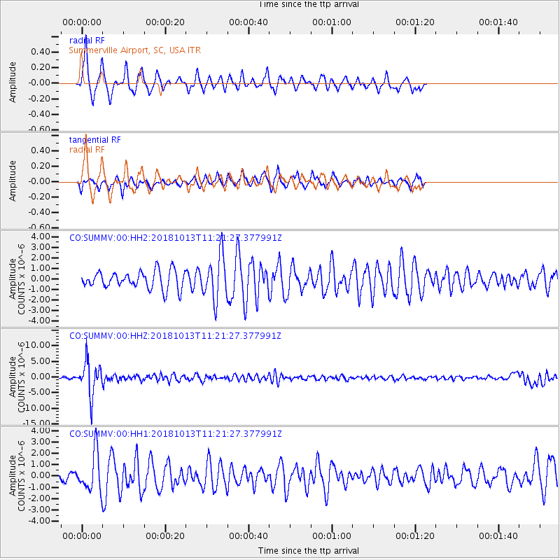
SUMMV Summerville Airport, SC, USA - Earthquake Result Viewer
*The percent match for this event was below the threshold and hence no stack was calculated.
| Earthquake location: |
Northwest Of Kuril Islands |
| Earthquake latitude/longitude: |
52.7/153.7 |
| Earthquake time(UTC): |
2018/10/13 (286) 11:10:19 GMT |
| Earthquake Depth: |
397 km |
| Earthquake Magnitude: |
6.7 Mi |
| Earthquake Catalog/Contributor: |
NEIC PDE/pt |
|
| Network: |
CO South Carolina Seismic Network |
| Station: |
SUMMV Summerville Airport, SC, USA |
| Lat/Lon: |
33.07 N/80.27 W |
| Elevation: |
17 m |
|
| Distance: |
82.5 deg |
| Az: |
43.213 deg |
| Baz: |
330.248 deg |
| Ray Param: |
$rayparam |
*The percent match for this event was below the threshold and hence was not used in the summary stack. |
|
| Radial Match: |
74.62486 % |
| Radial Bump: |
290 |
| Transverse Match: |
64.354774 % |
| Transverse Bump: |
293 |
| SOD ConfigId: |
3045211 |
| Insert Time: |
2018-10-27 11:19:22.744 +0000 |
| GWidth: |
2.5 |
| Max Bumps: |
400 |
| Tol: |
0.001 |
|
Signal To Noise
| Channel | StoN | STA | LTA |
| CO:SUMMV:00:HHZ:20181013T11:21:27.377991Z | 18.65256 | 5.4131283E-6 | 2.9020833E-7 |
| CO:SUMMV:00:HH1:20181013T11:21:27.377991Z | 2.4561927 | 1.7293979E-6 | 7.04097E-7 |
| CO:SUMMV:00:HH2:20181013T11:21:27.377991Z | 2.6171904 | 2.1569463E-6 | 8.2414573E-7 |
| Arrivals |
| Ps | |
| PpPs | |
| PsPs/PpSs | |


