You are here: Home > Network List > G - GEOSCOPE Stations List
> Station ATD Arta Cave - Arta, Republic of Djibouti > Earthquake Result Viewer
ATD Arta Cave - Arta, Republic of Djibouti - Earthquake Result Viewer
| Earthquake location: |
Java, Indonesia |
| Earthquake latitude/longitude: |
-6.0/112.0 |
| Earthquake time(UTC): |
2023/04/14 (104) 09:55:45 GMT |
| Earthquake Depth: |
594 km |
| Earthquake Magnitude: |
7.0 mww |
| Earthquake Catalog/Contributor: |
NEIC PDE/us |
|
| Network: |
G GEOSCOPE |
| Station: |
ATD Arta Cave - Arta, Republic of Djibouti |
| Lat/Lon: |
11.53 N/42.85 E |
| Elevation: |
610 m |
|
| Distance: |
71.0 deg |
| Az: |
284.319 deg |
| Baz: |
100.505 deg |
| Ray Param: |
0.052591614 |
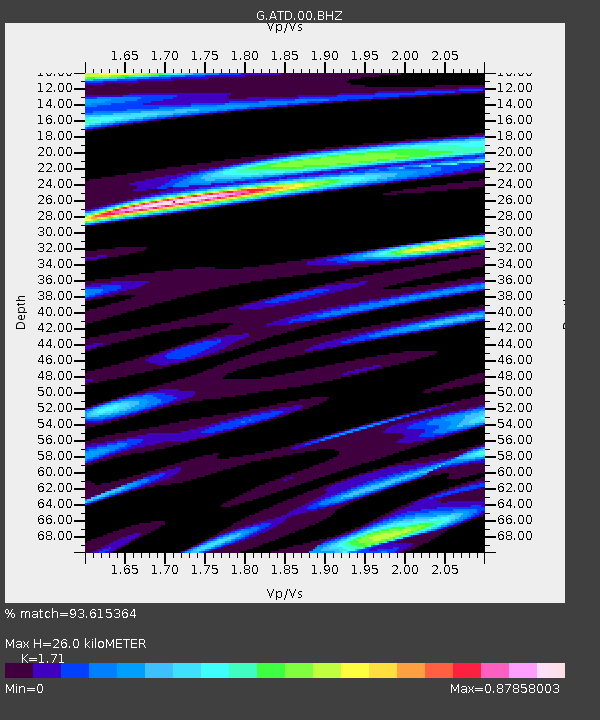
| Estimated Moho Depth: |
26.0 km |
| Estimated Crust Vp/Vs: |
1.71 |
| Assumed Crust Vp: |
6.375 km/s |
| Estimated Crust Vs: |
3.728 km/s |
| Estimated Crust Poisson's Ratio: |
0.24 |
|
| Radial Match: |
93.615364 % |
| Radial Bump: |
400 |
| Transverse Match: |
92.191605 % |
| Transverse Bump: |
400 |
| SOD ConfigId: |
30536071 |
| Insert Time: |
2023-04-28 13:07:43.902 +0000 |
| GWidth: |
2.5 |
| Max Bumps: |
400 |
| Tol: |
0.001 |
|
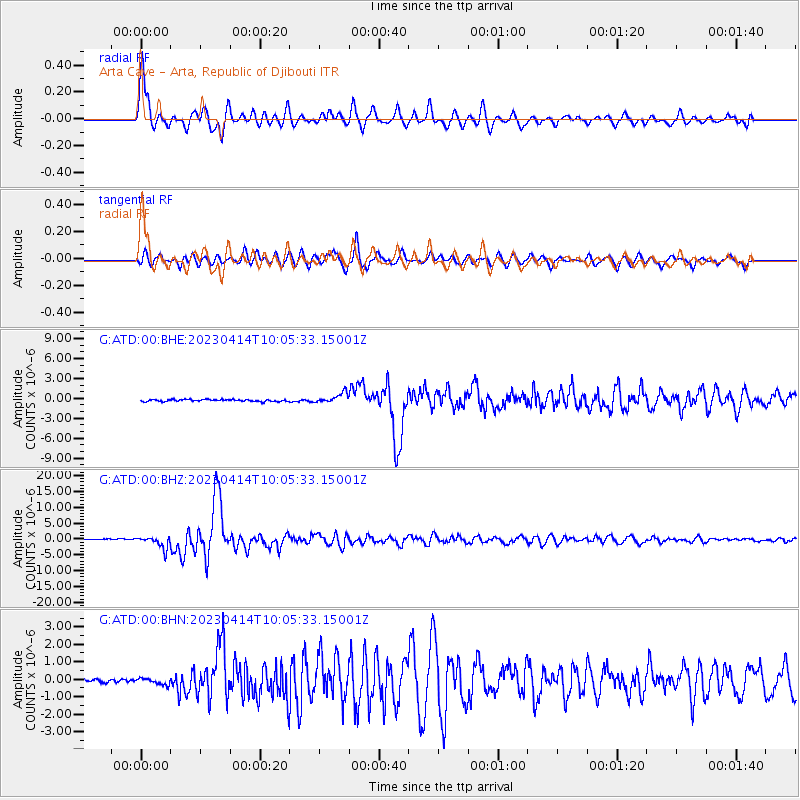
Signal To Noise
| Channel | StoN | STA | LTA |
| G:ATD:00:BHZ:20230414T10:05:33.15001Z | 15.166011 | 1.9200213E-6 | 1.2660028E-7 |
| G:ATD:00:BHN:20230414T10:05:33.15001Z | 1.5571797 | 1.7850337E-7 | 1.1463248E-7 |
| G:ATD:00:BHE:20230414T10:05:33.15001Z | 5.336981 | 7.6706624E-7 | 1.4372662E-7 |
| Arrivals |
| Ps | 3.0 SECOND |
| PpPs | 11 SECOND |
| PsPs/PpSs | 14 SECOND |


