You are here: Home > Network List > CB - China National Seismic Network Stations List
> Station DL2 Dalian,Liaoning Province > Earthquake Result Viewer
DL2 Dalian,Liaoning Province - Earthquake Result Viewer
| Earthquake location: |
Vanuatu Islands |
| Earthquake latitude/longitude: |
-13.6/167.2 |
| Earthquake time(UTC): |
2010/03/04 (063) 14:02:27 GMT |
| Earthquake Depth: |
176 km |
| Earthquake Magnitude: |
6.0 MB, 6.5 MW, 6.4 MW |
| Earthquake Catalog/Contributor: |
WHDF/NEIC |
|
| Network: |
CB China National Seismic Network |
| Station: |
DL2 Dalian,Liaoning Province |
| Lat/Lon: |
38.91 N/121.63 E |
| Elevation: |
65 m |
|
| Distance: |
67.4 deg |
| Az: |
322.842 deg |
| Baz: |
131.166 deg |
| Ray Param: |
0.056514468 |
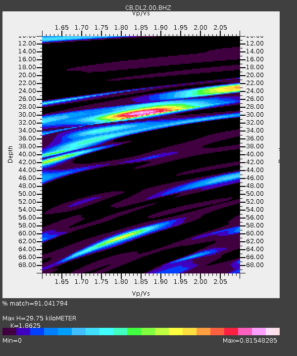
| Estimated Moho Depth: |
29.75 km |
| Estimated Crust Vp/Vs: |
1.86 |
| Assumed Crust Vp: |
6.134 km/s |
| Estimated Crust Vs: |
3.293 km/s |
| Estimated Crust Poisson's Ratio: |
0.30 |
|
| Radial Match: |
91.041794 % |
| Radial Bump: |
400 |
| Transverse Match: |
78.61422 % |
| Transverse Bump: |
400 |
| SOD ConfigId: |
308276 |
| Insert Time: |
2010-06-22 16:04:32.977 +0000 |
| GWidth: |
2.5 |
| Max Bumps: |
400 |
| Tol: |
0.001 |
|

Signal To Noise
| Channel | StoN | STA | LTA |
| CB:DL2:00:BHZ:20100304T14:12:32.77998Z | 28.135569 | 6.501392E-6 | 2.3107377E-7 |
| CB:DL2:00:BHN:20100304T14:12:32.77998Z | 11.312065 | 1.9488123E-6 | 1.7227732E-7 |
| CB:DL2:00:BHE:20100304T14:12:32.77998Z | 11.5255785 | 2.378746E-6 | 2.0638844E-7 |
| Arrivals |
| Ps | 4.3 SECOND |
| PpPs | 13 SECOND |
| PsPs/PpSs | 18 SECOND |


