You are here: Home > Network List > G - GEOSCOPE Stations List
> Station CLF Chambon la Foret observatory, France > Earthquake Result Viewer
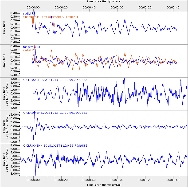
CLF Chambon la Foret observatory, France - Earthquake Result Viewer
*The percent match for this event was below the threshold and hence no stack was calculated.
| Earthquake location: |
Northwest Of Kuril Islands |
| Earthquake latitude/longitude: |
52.7/153.7 |
| Earthquake time(UTC): |
2018/10/13 (286) 11:10:19 GMT |
| Earthquake Depth: |
397 km |
| Earthquake Magnitude: |
6.7 Mi |
| Earthquake Catalog/Contributor: |
NEIC PDE/pt |
|
| Network: |
G GEOSCOPE |
| Station: |
CLF Chambon la Foret observatory, France |
| Lat/Lon: |
48.03 N/2.26 E |
| Elevation: |
145 m |
|
| Distance: |
76.7 deg |
| Az: |
340.732 deg |
| Baz: |
17.408 deg |
| Ray Param: |
$rayparam |
*The percent match for this event was below the threshold and hence was not used in the summary stack. |
|
| Radial Match: |
56.972523 % |
| Radial Bump: |
400 |
| Transverse Match: |
63.427444 % |
| Transverse Bump: |
384 |
| SOD ConfigId: |
3045211 |
| Insert Time: |
2018-10-27 11:19:57.895 +0000 |
| GWidth: |
2.5 |
| Max Bumps: |
400 |
| Tol: |
0.001 |
|
Signal To Noise
| Channel | StoN | STA | LTA |
| G:CLF:00:BHZ:20181013T11:20:56.799988Z | 7.084999 | 8.274941E-6 | 1.1679523E-6 |
| G:CLF:00:BHN:20181013T11:20:56.799988Z | 2.230444 | 3.5955397E-6 | 1.6120288E-6 |
| G:CLF:00:BHE:20181013T11:20:56.799988Z | 1.3381462 | 1.5448281E-6 | 1.154454E-6 |
| Arrivals |
| Ps | |
| PpPs | |
| PsPs/PpSs | |


