You are here: Home > Network List > IU - Global Seismograph Network (GSN - IRIS/USGS) Stations List
> Station PMG Port Moresby, New Guinea > Earthquake Result Viewer
PMG Port Moresby, New Guinea - Earthquake Result Viewer
| Earthquake location: |
Java, Indonesia |
| Earthquake latitude/longitude: |
-6.0/112.0 |
| Earthquake time(UTC): |
2023/04/14 (104) 09:55:45 GMT |
| Earthquake Depth: |
594 km |
| Earthquake Magnitude: |
7.0 mww |
| Earthquake Catalog/Contributor: |
NEIC PDE/us |
|
| Network: |
IU Global Seismograph Network (GSN - IRIS/USGS) |
| Station: |
PMG Port Moresby, New Guinea |
| Lat/Lon: |
9.40 S/147.16 E |
| Elevation: |
90 m |
|
| Distance: |
35.0 deg |
| Az: |
97.753 deg |
| Baz: |
272.917 deg |
| Ray Param: |
0.07445452 |
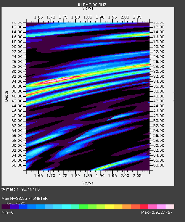
| Estimated Moho Depth: |
33.25 km |
| Estimated Crust Vp/Vs: |
1.72 |
| Assumed Crust Vp: |
6.122 km/s |
| Estimated Crust Vs: |
3.554 km/s |
| Estimated Crust Poisson's Ratio: |
0.25 |
|
| Radial Match: |
95.49496 % |
| Radial Bump: |
400 |
| Transverse Match: |
92.13866 % |
| Transverse Bump: |
400 |
| SOD ConfigId: |
30536071 |
| Insert Time: |
2023-04-28 13:10:01.763 +0000 |
| GWidth: |
2.5 |
| Max Bumps: |
400 |
| Tol: |
0.001 |
|

Signal To Noise
| Channel | StoN | STA | LTA |
| IU:PMG:00:BHZ:20230414T10:01:18.619004Z | 88.99114 | 7.975936E-6 | 8.962618E-8 |
| IU:PMG:00:BH1:20230414T10:01:18.619004Z | 17.64143 | 1.8018411E-6 | 1.0213691E-7 |
| IU:PMG:00:BH2:20230414T10:01:18.619004Z | 22.941534 | 3.5064452E-6 | 1.5284266E-7 |
| Arrivals |
| Ps | 4.2 SECOND |
| PpPs | 14 SECOND |
| PsPs/PpSs | 18 SECOND |


