You are here: Home > Network List > IU - Global Seismograph Network (GSN - IRIS/USGS) Stations List
> Station TATO Taipei, Taiwan > Earthquake Result Viewer
TATO Taipei, Taiwan - Earthquake Result Viewer

| Earthquake location: |
Java, Indonesia |
| Earthquake latitude/longitude: |
-6.0/112.0 |
| Earthquake time(UTC): |
2023/04/14 (104) 09:55:45 GMT |
| Earthquake Depth: |
594 km |
| Earthquake Magnitude: |
7.0 mww |
| Earthquake Catalog/Contributor: |
NEIC PDE/us |
|
| Network: |
IU Global Seismograph Network (GSN - IRIS/USGS) |
| Station: |
TATO Taipei, Taiwan |
| Lat/Lon: |
24.97 N/121.50 E |
| Elevation: |
160 m |
|
| Distance: |
32.2 deg |
| Az: |
16.282 deg |
| Baz: |
197.892 deg |
| Ray Param: |
0.075943455 |
| Estimated Moho Depth: |
27.75 km |
| Estimated Crust Vp/Vs: |
1.75 |
| Assumed Crust Vp: |
6.289 km/s |
| Estimated Crust Vs: |
3.599 km/s |
| Estimated Crust Poisson's Ratio: |
0.26 |
|
| Radial Match: |
88.00889 % |
| Radial Bump: |
400 |
| Transverse Match: |
74.344765 % |
| Transverse Bump: |
400 |
| SOD ConfigId: |
30536071 |
| Insert Time: |
2023-04-28 13:10:07.773 +0000 |
| GWidth: |
2.5 |
| Max Bumps: |
400 |
| Tol: |
0.001 |
|
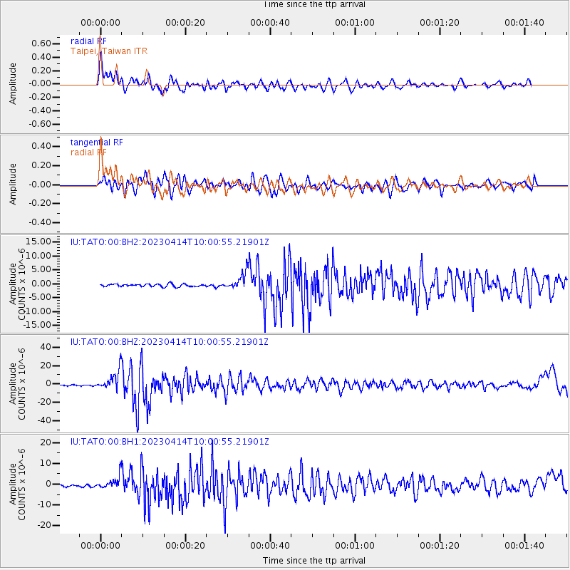
Signal To Noise
| Channel | StoN | STA | LTA |
| IU:TATO:00:BHZ:20230414T10:00:55.21901Z | 21.621986 | 1.0698204E-5 | 4.947836E-7 |
| IU:TATO:00:BH1:20230414T10:00:55.21901Z | 6.1881065 | 3.1701413E-6 | 5.1229586E-7 |
| IU:TATO:00:BH2:20230414T10:00:55.21901Z | 6.8913226 | 3.1766065E-6 | 4.6095747E-7 |
| Arrivals |
| Ps | 3.5 SECOND |
| PpPs | 11 SECOND |
| PsPs/PpSs | 15 SECOND |


